


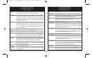

Each data window can either be empty or contain one of the following
(varies by position and by view):
NOTE: You can set these 5 readouts with navigation mode settings as well, so that,
when you are navigating, these views contain navigation data instead of the regular
settings. See Navigation X-Press™ menu: Select Nav Readouts for more information.
Bearing Bearing is the direction to a destination waypoint measured in degrees from North (i.e.
321°, where 000° is North, 090° East, 180° is South, 270° is West).
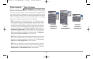
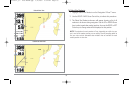
CMG/SMG Course Made Good/Speed Made Good. Course Made Good is the angle between the
starting point on a route and the current position of the boat. The goal is to have CMG and
Track equal to the same number. See the Course Made Good illustration. Speed Made Good
is the distance from the starting waypoint on the route divided by the time elapsed since
starting navigation on the route.
COG Course Over Ground. Course Over Ground is the current direction the boat is traveling
measured in degrees from North (i.e. 321°, where 000° is North, 090° East, 180° is
South, 270° is West). When the Course Over Ground is equal to Bearing, the boat is said
to be “On Course” and will arrive at the destination in the most efficient manner. See the
Glossary for more information.
Off Suppresses the readout so that no data shows in that position.
Position Position is the current location (latitude, longitude) determined by GPS.
SOG Speed Over Ground. Speed Over Ground is the measurement of the boat’s progress across
a given distance, and is the speed measurement provided by GPS; accurate destination
times can be derived from this measurement. See the Glossary for more information.
TRK/CMG Track/Course Made Good. The Track Line is the desired line of travel between two waypoints,
and represents the most efficient path between the two points because it is a straight line. The
TRK is measured in degrees. See above for an explanation of Course Made Good.
TTG Time To Go. Time To Go is the estimated time required to reach the destination waypoint.
TTG is calculated using the SOG and DTG.
Temp The current detected water temperature.
Aux. Temp The current detected water temperature from an optional-purchase Temperature Probe or
Temp/Speed accessory.
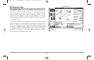
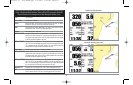
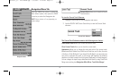
8 Adjustable Data Windows, Used by Bird's Eye Big Digits and Chart Big
Digits Views; 3 Adjustable Data Windows, Used by Bird's Eye Instrument
View and Chart Instrument View; Navigation and Non-Navigation Modes
COG Course Over Ground; Course Over Ground is the current direction the boat is traveling
measured in degrees from North (i.e. 321°, where 000° is North, 090° East, 180° is
South, 270° is West). When the Course Over Ground is equal to Bearing, the boat is said
to be “On Course” and will arrive at the destination in the most efficient manner. See the
Glossary for more information.
Off Suppresses the readout so that no data shows in that position.
Position Position is the current location (latitude, longitude) determined by GPS.
SOG Speed Over Ground; Speed Over Ground is the measurement of the boat’s progress across
a given distance, and is the speed measurement provided by GPS; accurate destination
times can be derived from this measurement. See the Glossaryfor more information.
Temp The current detected water temperature from an optional-purchase Temperature Probe or
Temp/Speed accessory.
Aux. Temp The current detected water temperature from an optional-purchase Temperature Probe or
Temp/Speed accessory.
Time The current time.
Time + Date The current time and date.
Triplog Displays the triplog, which measures the elapsed time since last reset, the distance traveled
since last reset, and average speed during timed interval.
Voltage Power supplied to the control head.
Water Speed The current speed of the water as it flows past the boat.
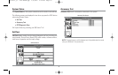
5 Selectable Data Windows, Used by Standard Chart Views;
Non-Navigation Mode
51
531569-1_B - 955c ManE.qxp 3/4/2007 5:04 PM Page 51