


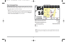

NOTE: You may also choose Chart Big Digits View or Chart No Readouts View if
you prefer.
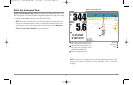
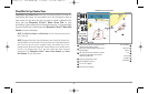
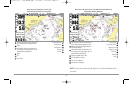
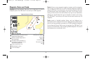
Chart View with Active Cursor, with Optional-Purchase Navionics®
Cartography, Showing Navigation
COG: Course Over Ground; the current direction the
boat is traveling measured in degrees from North.
Cursor Info Box
1
8
BRG: Direction to Destination Waypoint Relative to
North Reference Waypoint
Lat and Long of Cursor
2
9
SOG: Speed Over Ground; the measurement of the
boat’s progress across a given distance, and is the
speed measurement provided by GPS.
Distance to Cursor
3
10
Latitude and Longitude Position of Boat
Bearing of Cursor
4
11
NEXT: Next Waypoint in the Route
Cursor Icon
5
12
TTG: Time to Go to Waypoint
Boat Icon
6
13
DTG: Distance to Go to Waypoint
Route
7
14
1
2
4
5
6
3
7
8
9
10
11
12
13
14
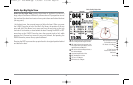
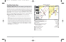
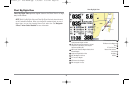
Chart View with Active Cursor, shown with
Optional-Purchase Navionics® Cartography
COG: Course Over Ground; the current direction the
boat is traveling measured in degrees from North.
Lat and Long of Cursor
1
7
Voltage
Distance to Cursor
2
8
SOG: Speed Over Ground; the measurement of the
boat’s progress across a given distance, and is the
speed measurement provided by GPS.
Bearing of Cursor
3
9
Position
Cursor Icon
4
10
Time
Boat Icon
5
11
Cursor Info Box
6
1
2
4
5
6
3
7
8
9
10
11
27
531569-1_B - 955c ManE.qxp 3/4/2007 5:03 PM Page 27