


NOTE: The built-in UniMap™ does not contain any Port, Tide or Current
information. This information is only available from optional-purchase
MMC/SD cards.
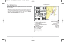
Nearest Port: The position and services information for the nearest port to
your present position will be displayed. Press the EXIT key to remove the
information box and the Bullseye Cursor will be centered over the port
position. The Cursor Information Boxes will indicate the distance and bearing
to the port from your present position. Press the EXIT key again to return to
the Chart View.
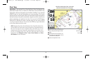
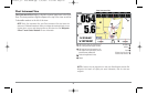
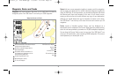
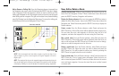
Nearest Tide Station: Tide information for the nearest tide station to your
present position will be displayed. This includes the position of the station
and the times of the high and low tides for today’s date. A tide graph is
also displayed showing the rise and fall of the tides for the 24 hour time
period encompassing the date. You can change the date to look at tide
information before or after the date displayed by pressing the LEFT or
RIGHT Cursor key respectively. Press the EXIT key to remove the
information box and the Bullseye Cursor will be centered over the tide
station position. The cursor information boxes will indicate the distance
and bearing to the tide station from your present position. Press the EXIT
key again to return to the Chart View.
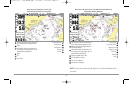
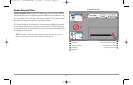
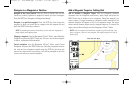
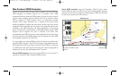
Nearest Current Station: Current information for the nearest current station
to your present position will be displayed. This includes the position of the
station and the current changes for today. Two graphs are also presented
that show the time, direction and flow speed of the current changes for the
24 hour time period of today’s date. You can change the date to look at
current information before or after the date displayed by pressing the LEFT
or RIGHT Cursor key respectively. Press the EXIT key to remove the
information box and the Bullseye Cursor will be centered over the current
station position. The Cursor Information Boxes will indicate the distance and
bearing to the current station from your present position. Press the EXIT key
again to return to the Chart View.
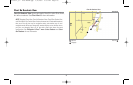
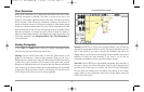
Introduction to Navigation
Use the 900 Series™ to establish waypoints at areas of interest and to
navigate to those waypoints via a saveable route (representing the shortest
intended distance between waypoints). You can also view and save tracks,
which represent the actual path of the boat.
33
531569-1_B - 955c ManE.qxp 3/4/2007 5:03 PM Page 33