


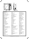

Northstar Explorer 657 Installation and Operation Manual90
Appendix C - Glossary and navigation data
Attention Area - An important area on a chart,
such as a restricted anchorage or a shallow area
(see section 17-2).
AIS - Automatic Identification System. A System
where vessel information (location, course, speed,
etc.) is broadcast by VHF radio, for use by other
vessels in navigation and collision avoidance.
Bathymetric line - A depth contour line on
the chart.
Chart card - A plug-in card that stores chart data
for a region (see section 1-3).
C-MAP™ chart card - See Chart card.
C-MAP™ user card - See User card.
CPA - Closest Point of Approach. The closest
distance two vessels will come to each other
based on their current course and speed.
Cursor - A
symbol on the display (see section
3-2).
DGPS - Differential Global Positioning System. A
navigation tool based on GPS with some errors
corrected (see section 7).
DSC - Digital Selective Calling. A feature of
marine radios enabling communication between
specific vessels, as well as distress alerts.
Goto - A simple way of navigating straight to a
waypoint or to the cursor position (see section
3-1).
GPS - Global Positioning System. A satellite-
based navigation tool (see section 7).
Leg - The straight segments of a route between
waypoints. A route with four waypoints has three
legs.
MMSI - Maritime Mobile Service Identity. Unique
identification number for a vessel, for use in
Digital Selective Calling.
MOB - Man overboard.
MOB function - Starts navigating back to the
place where someone fell overboard (see section
2-4).
NavBus - A way of connecting Northstar
instruments together to share data (see section
18-9).
NMEA - National Marine Electronics Association.
NMEA 0183 - A standard for interfacing marine
electronic devices (see section 18-10).
Route: Two or more waypoints linked in
sequence to form a course for the boat (see
section 6).
SmartCraft - A feature of Mercury Marine
engines for monitoring engine performance.
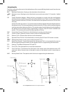
TCPA - Time to Closest Point of Approach.
Time until the closest point of approach for two
vessels.
User card - A plug-in card that stores waypoints,
routes and tracks (see section 1-2).
UTC - Universal Time Coordinated or Coordinated
Universal Time, which is a standard world time,
formerly called Greenwich Mean Time (GMT).
VHF - Very High Frequency. The frequency range
used by marine radios.
Waypoint - A position that you can set on the
657 chart, for example a fishing spot or a point on
a route (see section 5).
Glossary