


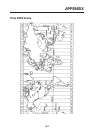
SP - 2
Ship’s speed in and out alarms
(8) Electronic Chart FURUNO chart card or NAVIONICS chart card available
(9) Information Display Ship’s L/L position (Loran C or A TDs also available)
Date and Time, Ship’s speed, Chart scale, Waypoint L/L position,
Range and bearing to destination waypoint
Cursor intersection L/L position
Range and bearing to cursor intersection
Water temperature and water depth (sensor data required)
5. DATA INPUT / OUTPUT
(1) Number of ports Input: 3 Ports, Output: 4 ports
(2) Input data DGPS: RTCM SC104
DATA IN/OUT: NMEA0183, NMEA0180/0182 and CIF
AP IN/OUT: NMEA0183
(3) Output data DGPS: NMEA0183, NMEA0180/0182 and CIF
DATA IN/OUT: NMEA0183, NMEA0180/0182 and CIF
DATA OUT: NMEA0183, NMEA0180/0182 and CIF
AP IN/OUT: NMEA0183 and NMEA0180S
6. POWER SOURCE
(1) GD-3300: 12-24 VDC(-10%,+30%); 1.1-0.6 A
(2) GP-3300: 12-24 VDC(-10%,+30%); 1.3-0.7 A
(3) For AC Source 100/110/115/200/220/230 VAC, 1 phase, 50/60 Hz
(optional rectifier required)
7. ENVIRONMENTAL CONDITIONS
(1) Useable Temperature Antenna unit: -25°C to + 70°C
Display unit: -15°C to +55°C
(2) Relative Humidity 95%(40°C)
(3) Waterproofing Antenna unit (GP-3300 only): IEC60529 IPX6
Display unit: IEC60529 IPX2
8. COATING COLOR
(1) Display Unit Cover: Munsell 2.5GY5/1.5
Panel: N3.0