


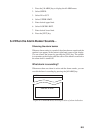
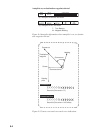

7-4
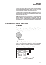
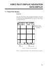
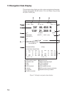
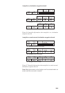
7.2 Navigation Data Display
The navigation data display provides various navigation information,
input by a navigation aid and sensors. You can display it by pressing
the [NAV DATA] key.
NAV DATA
2D WGS-84
10 - APR - 1998 03 : 02 : 22 DOP = 1.3
34° 44. 454 N
135° 21. 288 E
L/L 0.000’N 0.000’E
SPEED/CRS 10.5KTS / 196.4° (MAG)
TEMP/DEPTH /
TTG
ETA H M / .
SATELLITE PREDICTION
24 HOURS OK
FREQ DEVIATION - 270Hz
SAT RECEIVE CONDITION
No. STAT ELV AZM LVL No. STAT ELV AZM LVL
03 USE 28 034 0789 20 00 000 0089
14 00 000 0127 17 TRK 23 085 0466
18 TRK 08 321 0638 28 USE 51 209 0892
11 USE 11 196 0511 25 USE 47 120 1041
Data Rx : NG Ref Sta : OK
GPS receiver status
Geodetic chart
Data
Time
DOP threshold
Latitude
Longitude
Position correction
Speed/course
Water temp/water depth
TTG to waypoint
ETA to waypoint
GPS satellite forecast
GPS receiver frequency deviation
Satellite receiving condition
Figure 7-4 Sample navigation data display