


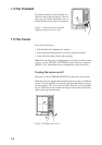
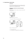

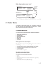
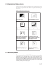

1-12
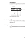
FL (2) 12S 15M
Visibility in nautical miles
(Example: 15 miles)
Period in seconds (Example: 12 seconds)
Number of flashes (Example: 2)
FL : Flashing
F : Fixed light
F FL : Fixed and Flashing light
MO : Morse code light
Oc : Occulting light
Figure 1-15 How to interpret buoy, lighthouse data
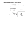
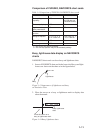
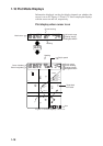
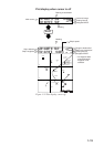
1.12 The Data Window
The data window at the top of the display shows various navigation
information. What information is displayed depends on whether the
cursor is on or off and the status of the [PLOT] key or [VIDEO PI-
LOT] key. Figures 1-16 and 1-17 show what appears in the data win-
dow under those conditions.
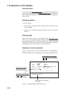
Data shown when cursor is on
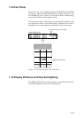
DATA DISPLAY (2)
+ CURSOR LAT CURSOR BEARING CHART SCALE
CURSOR LON SHIP'S HEADING
PLOTING INTERVAL
NAVIGATOR/HDOP
+ CURSOR LAT HEADING
CURSOR LON SPEED
RANGE TO CURSOR
BEARING TO CURSOR
PLOTTING INTERVAL
NAVIGATOR/HDOP
DATA DISPLAY (1)
PLOT
PLOT
PLOT
NO DISPLAY
Figure 1-16 Information displayed in data window when cursor is on