


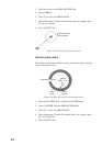
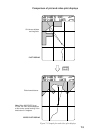
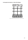

7-3
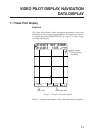
Comparison of plot and video pilot displays
34° 44.463’ N 314.5°
135° 21.288’ E 0.4KTS
0.14NM
225.0°
0.01NM
2D 1.3
34° 44.463’ N 314.5°
135° 21.288’ E 0.4KTS
0.14NM
225.0°
0.01NM
2D 1.3
Grid shows latitude
and longitude.
VIDEO
PILOT
Grid shows distance.
Note: When NAVIONICS chart
is used, the chart data disappears
at this mode, except bearing of the
destination is 0 degrees.
PLOT DISPLAY
VIDEO PILOT DISPLAY
Figure 7-3 Sample plot and video pilot displays