


4-11
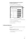
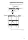
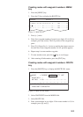
Displaying range and bearing to destination
waypoint
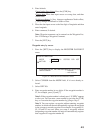
Press the [PLOT] key to display the DATA DISPLAY (2).
36° 34.000’ N 340.5°
134° 20.524’ E 10.0KTS
0.215NM
176.5
°
0’ 10"
2D 1.2
40 42
48
44
Range to destination
Waypoint
Bearing to destination
waypoint
Heading
00
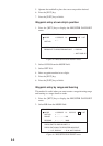
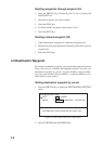
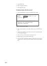
36° 34.000’ N 176.5° 14.5NM
134° 20.524’ E 340.5°
0’ 10"
2D 1.2
DATA DISPLAY (1)
PLOT
DATA DISPLAY (2)
Bearing to destination
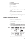
Figure 4-12 Location of destination waypoint information