


1-19
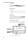
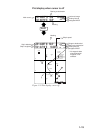
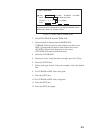
Plot display when cursor is off
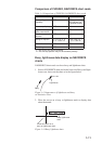
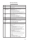
36° 44.257’ N 50.5°
134° 40.719’ E 10.0KTS
1.46NM
59.8
°
0.10NM
2D 1.2
40 42
48
44
Range to destination*
Bearing to destination*
Plotting interval
Navigator/HDOP
Heading
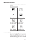
H
L
L
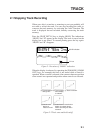
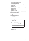
MARK
MARK
MARK
6
MARK
07
WAYPOINT
MARK
1
08
WAYPOINT
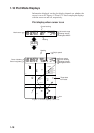
LINE
TRACK
CURSOR
PLUS MARK
+
OWN SHIP
MARK
COURSE
VECTOR
DESINATION
WAYPOINT
(SELECTED BY
CURSOR)
IDEAL COURSE TO
DESTINATION
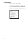
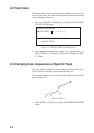
36° 44.257’ N 59.8° 35.92NM
134° 40.719’ E 50.5°
0.10NM
GPS 1.2
Ship’s latitude
Ship’s longitude
PLOT
Horizontal range
Plotting interval
Navigator/HDOP
Mark cursor
Heading
Bearing to destination
Ship’s speed
*: No waypoint data
when destination
waypoint is not
selected.
Figure 1-21 Plot display, cursor off