


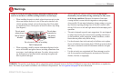
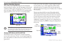
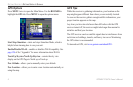
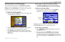

The progress of satellite acquisition is shown in three stages:
•
No signal strength bars—the receiver is looking for the
satellites indicated.
•
White signal strength bars—the receiver has found the
satellite and is collecting data.
•
Green signal strength bars—the receiver has collected the
necessary data from this satellite.
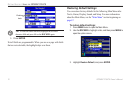
When the GPSMAP 378/478 collects the necessary data from the
best satellites in view to calculate a x, the status eld indicates the
status of the receiver. The unit then updates the location, date and
time.
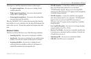
Receiver Status
The Receiver Status eld shows one of the following conditions:
•
Searching the Sky—the receiver is looking for satellites.
•
AutoLocate—the receiver is looking for any satellite whose
almanac was collected, which can take up to ve minutes.
•
Acquiring Satellites—the receiver is looking for and
collecting data from satellites visible at its last known or
initialized location but has not acquired a x.
•
2D GPS Location—At least three satellites were acquired
and a two-dimensional position x was calculated.
“2D Differential” appears when you are receiving DGPS
corrections in 2D mode, and a “D” appears on the strength bar
of satellites being corrected.
•
3D GPS Location—At least four satellites were acquired
and a three-dimensional x was calculated. “3D Differential”
appears when you are receiving DGPS corrections in
3D mode, and a “D” appears on the strength bar of satellites
being corrected.
•
Lost Satellite Reception—the receiver is no longer tracking
enough satellites for a 2D or 3D x.
•
Receiver Not Usable—the receiver is unusable, possibly due
to interference or abnormal satellite conditions. Turn the unit
off and back on to reset it.
• Simulating GPS—the receiver is in Simulator Mode.
•
GPS Off—the GPS receiver is turned off.
GPSMAP 378/478 Owner’s Manual 5
gettIng stArted > gettIng sAtellIte sIgnAls