


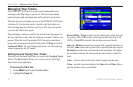


MarIne Mode PaGeS
Five pages are available in Marine Mode—Map, Compass,
Highway, Active Route, and Position Data. An optional XM Audio
Page can be enabled. A Sonar Page is available when a GSD 21
Sounder Module is connected.
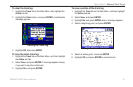
Map Page
When you turn on the GPSMAP 378/478, the Map Pages appears
after the unit acquires a satellite signal. The position marker ( )
shows your current location on the map.
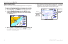
The Map Page shows map information (digital cartography) that
includes navaids, lakes, rivers, coastlines, cities, and highways. Use
the dedicated zoom keys (IN and OUT) to adjust the Map Page
scale.
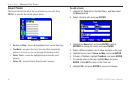
Two map operating modes, Position Mode and Pan Mode, determine
what cartography is shown on the map display. Position Mode
pans the map to keep your present location in the display area.
The position marker ( ) shows your travel on the Map Page. The
GPSMAP 378/478 always turns on in Position Mode, with the last
known location centered on the map. When you press the ROCKER,
the GPSMAP 378/478 enters Pan Mode, which moves the map to
keep the white arrow (map pointer) within the display area.
The system has built-in BlueChart g2 charts. Optional Garmin data
cards and MapSource CD-ROMs enhance the versatility of your
GPSMAP 378/478. With optional MapSource information and
BlueChart g2 you can view information for outside the US that is
not already preloaded.
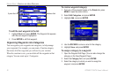
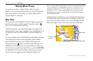
In Marine Mode, by default, ve user-selectable data elds appear
on the right side of the screen that can be congured to show any
one of the possible data options. You can also add additional data
elds to the page or select a full screen map without data elds.
Map Page
Data elds
Map scale
Current
location
38 GPSMAP 378/478 Owner’s Manual
MArIne Mode PAges > MAP PAge