


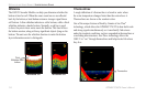

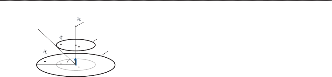
Satellite Information
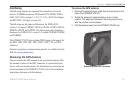
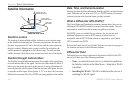
Satellite Sky View
45°
90°
Outer ring -
the horizon
Inner ring- 45°
above the horizon
Center dot - 90°
above the horizon
Satellite Location
The location of each available satellite is shown over two location rings
on the Satellite Information Page. The outer ring represents the horizon,
the inner ring represents 45° above the horizon, and the center represents
directly overhead. When the unit is using a satellite for navigation, the
satellite number is highlighted on the location rings. The unit can show
satellite location with North or your current track at the top of the display.
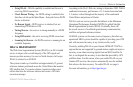
Satellite Strength Indicator Bars
The Satellite Strength Indicator Bars show the strength of the signal being
received and the status of the signal. The bars are either shaded or lled. A
hollow gray bar means the unit is in the process of storing orbital data it is
receiving from the satellite signal. When the bar turns solid green, the unit
is using the satellite signal for navigation. A “D” in or above the bar means
differential corrections (WAAS or DGPS) are being applied to that satellite.
Date, Time, and Current Location
The unit gets date and time information from the satellite’s on-board atomic
clock. When the unit has achieved a 2-D or 3-D GPS location, the current
location is shown in the location format you have selected.
What is Differential GPS (DGPS)?
The United States and Canadian governments (among others) have set up
Differential GPS (DGPS) stations to transmit correction signals. They are
operational in coastal areas and on many navigable river systems.
The DGPS system is available for use without a fee, but you do need
additional equipment to receive DGPS signals; a beacon receiver
compatible with the RTCM format sentences supported by your Garmin
GPS is needed to use DGPS.
Refer to the United States Coast Guard’s Web site (www.navcen.uscg.gov/)
for locations and status of the differential stations.
Differential Field
Differential receiver status is indicated in the bottom left eld of the GPS
tab and will show one of the following conditions:
• None—no optional beacon receiver is attached or enabled in
the Interface sub tab on the Main Menu—Setup tab or WAAS
is disabled.
•
Searching for WAAS—WAAS is enabled and the receiver is
searching for WAAS signal.
122 GPSMAP 378/478 Owner’s Manual
APPendIX > sAtellIte InforMAtIon