


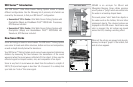
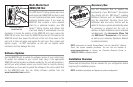

QuadraBeam PLUS™ Sonar
(Standard with 957c Combo models, optional-
purchase for 917c Combo models only)
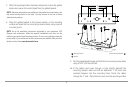
Your 900 Series™ 957c Combo is
shipped with a QuadraBeam PLUS™
transducer. QuadraBeam PLUS™ sonar
provides an extremely wide (90°) area
of coverage. QuadraBeam PLUS™
starts with two fan-shaped 35° 455 kHz
Side Structure locating sonar beams to
spot fish, bait and structure to the left
and right of the boat over an area of the
bottom that’s always equal to twice
your depth.
For a detailed view below the boat, QuadraBeam PLUS™ uses DualBeam
PLUS™ technology, with precision 20° and wide 60° beams. QuadraBeam
PLUS™ finds more fish faster, and can even tell you where to put your bait
by showing if fish are to the left, right or directly beneath your boat.
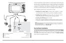
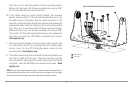
Universal Sonar 2
Your 900 Series™ Fishing System supports Universal Sonar 2, a state-of-the-
art, integrated and protected transducer that is built into the lower unit of
Minnkota trolling motors. With Universal Sonar 2, all wiring is concealed
inside the indestructible composite shaft—out of sight and out of harm’s
way, with no clamps, ties, or exposed wires. Universal Sonar 2 features new
temperature sensing and the performance of DualBeam PLUS™ technology.
An expanded view and greater bottom detail gives you a totally new
perspective of the water below, along with optimal sonar performance to
help you find fish.
How GPS and Cartography Work
Your 900 Series™ Fishing System also supports GPS and chartplotting, and
uses GPS and sonar to determine your position, display it on a grid, and
provide detailed underwater information. The Global Positioning System
(GPS) is a satellite navigation system designed and maintained by the U.S.
Department of Defense. GPS was originally intended for military use;
however, civilians may also take advantage of its highly accurate position
capabilities, typically within +/- 10 meters, depending on conditions. This
means that 95% of the time, the GPS receiver will read a location within 10
meters of your actual position. Your GPS Receiver also uses information from
WAAS (the Wide Area Augmentation System), EGNOS (the European
Geostationary Navigation Overlay Service), and MSAS (the MTSAT Satellite
Augmentation System) satellites if they are available in your area.
3