


10-2
www.topconpa.com
Weather Station Operation/Installation Manual
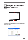
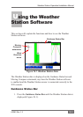
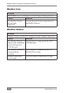
The following weather data will be displayed on the Guidance Status
Bar:
• WS — Displays actual wind speed in mph or kph (see ‘Units’,
page 9-3). The wind speed displayed is the actual wind speed. If
the vehicle is moving the Guidance software takes this into
account and calculates the vehicle’s GPS speed and heading
direction and displays the actual wind speed.
• T — The temperature is displayed in Fahrenheit (F) or Celsius
(C) (see ‘Units’, page 9-3)
• RH — The relative humidity (%) is displayed
• DT — Delta T is displayed.
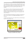
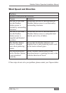
Moving Compass
When the vehicle is moving the Moving Compass is displayed on the
Guidance Coverage Map screen.
Wind Direction
The ‘red arrow’ on the Moving Compass indicates the wind
direction. Like wind speed the wind direction takes into account the
vehicle’s GPS heading to display the actual wind direction.
Recording the Weather Station Data
For the Guidance to record the weather data with the Guidance
Coverage Map the Weather Station software must be enabled (see
‘Enabling the Weather Station Software’, page 9-2).
When the Guidance is drawing the Coverage Map on the Guidance
screen, then once a minute the weather data is saved automatically with
the Coverage Map data, in the GDX le.