


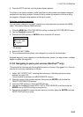
3. PLOTTER OPERATION
3-41
6. Press the GOTO soft key, and the plotter display appears.
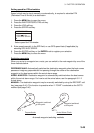
For either of the above methods, a solid light-blue line with arrows runs between waypoint
selected and own ship’s position. Arrows on the line show the direction to follow to get to
the waypoint. Waypoint data appears at the top of screen.
Selecting an external waypoint
You can select a waypoint (or route) entered at an external plotter connected with NMEA
cable. This function requires RMB sentence.
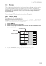
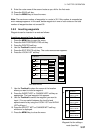
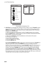
1. Press the MENU key, PLOTTER SETUP soft key to show the PLOTTER SETUP menu.
2. Use the Trackball to select QP.
3. Press the ENTER soft key or ENTER knob to show the QP window.
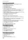
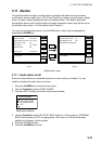
QP
EXT WPT (RMB)
INTERNAL
QP window
4. Select EXT WPT (RMB).
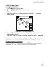
5. On a connected external plotter, set a waypoint (or route) as the destination.
Selected waypoint (route) appears on the NavNet plotter screen. (on radar screen, a lollipop
appears to show the waypoint.)
3.10.3 Navigating to ports, port services (NavChart
TM
only)
The port service list shows services available at ports or harbors. (See page 3-13.) You can
use the list to set your destination as follows:
1. Select “35 PTS/PORT SVC” following the procedure in “Selecting quick point entry
method” on page 3-39.
This procedure is necessary for NEAR SERVICE function.
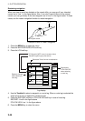
2. Place the cursor on the location desired, then press the ENTER knob to show the
OBJECT INFORMATION window.
3. Press the FIND soft key to show the FIND window.
4. Operate the trackball to choose PORT LIST or PORT SERVICE, and then press the
ENTER knob or ENTER soft key to show the list.
5. Operate the trackball to choose the port (service), and then press the ENTER knob and
GOTO PORT soft key in order.