


3. PLOTTER OPERATION
3-16
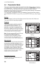
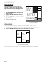
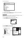
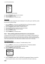
Color
white
Height
7. 00 Meters
Light characteristic
occulting
XXXXXXXX
XXXXXXXX
Navigation mark, fixed
Light.
Sample lighthouse data
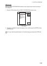
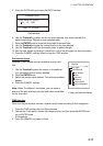
5. If necessary, move the Trackball downward or upward to scroll the window.
6. Press the CANCEL soft key twice to finish.
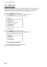
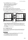
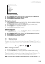
Tide information
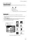
The C-MAP NT chart card provides for calculation of the tide heights for any date.
Additionally it displays the times of sunrise and sunset.
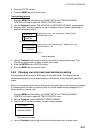
1. Use the Trackball to place the cursor on a Tide icon (
T
).
2. Push the ENTER knob to open the Objects window.
OBJECTS
Tide height
Cartographic area
Source of data
Objects window
3. Use the Trackball to select Tide height.
4. Push the ENTER knob to open the TIDE window.
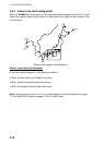
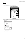
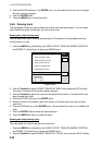
Objects
Port area
Port/Marine
Fuel station
Water
Electricity
Showers
Pubric toilets
Pubric telephone
34 24. 3456 N 359.9 NU
124 24. 3456 W 59.9kt 024nm
+
Time: 04:35L
Height: 0.45ft
Draught: 0.65ft
28/10/98 -
UTC
05
43° 32.860N
010° 18.022E
Port information
LIVORNO (LEGHORN)
High Water(max)
0.86ft(13:30 L)
Low Water(min)
0.35ft(21:00 L)
Sunrise
07:52L
Sunset
16:53 L
0.86
0.74
0.61
0.48
0.35
048
12
16 20 24
RETURN
DATE
V
ertical
C
ursor
TIDE
Tide window