


8. MAINTENANCE, TROUBLESHOOTING
8-12
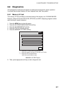
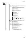
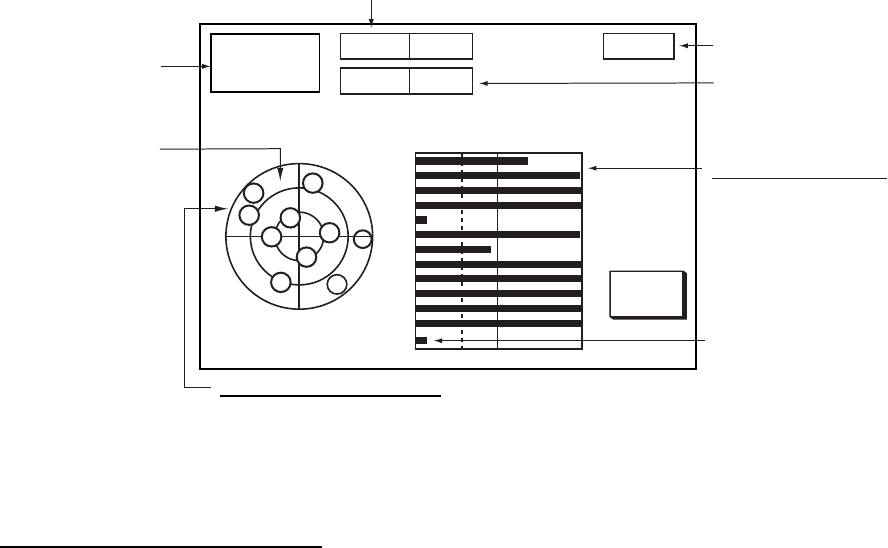
8.9 GPS Status Display
The GPS status display provides data about the GPS satellites. It is available with
connection of a FURUNO BB GPS receiver or a GPS receiver outputting the data sentence
GSA or GSV.
1. Press the MENU key.
2. Press the SYSTEM CONFIGURATION, NAV OPTION and GPS SENSOR SETTINGS
soft keys to display the GPS SENSOR SETTINGS menu.
3. Press the GPS STATUS soft key.
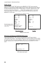
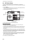
RETURN
23:59:59
APR 10 2009
Date
and
Time
DOP value
Rx signal level table
Bars show satellite
signal levels. Satellites
whose signal level
extends past 40 are
used to fix position.
GPS antenna height
Satellite position diagram
Satellites used for fixing position are circled.
23
12
29
27
01
17
26
05
20
21
30
28
123
30
40 50
DOP
1.2
ALT
1 m
W
N
S
E
21
12
23
20
29
05
27
17
28
30
01
26
SAT
No.
SNR
GPS 3D
GPS position fix
W
WAAS satellite
("W")
WAAS satellite
(Three digits)
GPS status display
4. Press the RETURN soft key to quit the GPS status display.
About the GPS status display
• This display is available with a FURUNO BB GPS receiver or other GPS receiver
connected via LAN and outputting NMEA 0183 data.
• The receive signal level table shows the receive signal strength of 12 GPS satellites and
one WAAS satellite. (GSA, GSV sentence necessary for GP-330B, WS-200 and other
GPS receiver.)
• The WAAS satellite whose GSA data is first received, in case of the GP-330B, WS-200
and other GPS receiver, is used for the display. When there is no GSA sentence and the
GSV sentence contains data from several WAAS satellites, the WAAS satellite having the
highest elevation and best SNR is used for the display.
• The satellite position diagram shows the arrangement of GPS, GLONASS and WAAS
satellites in the sky. A total of 36 satellites can be displayed. The type of satellite and
number of satellites that can be displayed are as follows:
GPS, 1-36; GLONASS, 65-96, WAAS, 1
• ALT indication is only available with GP-320B.