


ii GPSMAP
®
4000/5000 Series Owner’s Manual
Introduction
Table of Contents
Introduction ................................................i
Tips and Shortcuts ...........................................i
Manual Conventions ........................................i
Quick Links ......................................................i
Getting Started ..........................................1
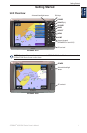
Unit Overview ..................................................1
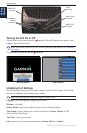
Turning the Unit On or Off ...............................2
Initializing Unit Settings ...................................2
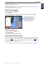
Adjusting the Backlight ....................................3
Acquiring GPS Satellite Signals ......................3
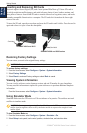
Inserting and Removing SD Cards .................4
Restoring Factory Settings ..............................4
Viewing System Information ...........................4
Using Simulator Mode .....................................4
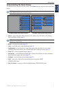
Understanding the Home Screen ....................5
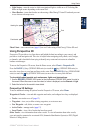
Using Charts .............................................6
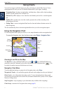
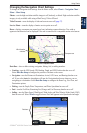
Using the Navigation Chart .............................6
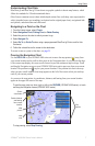
Changing the Navigation Chart Settings .........9
Using Radar Overlay .....................................12
Using Tracks .................................................12
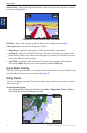
Using BlueChart g2 Vision ............................14
Using Mariner’s Eye 3D ................................14
Using Fish Eye 3D ........................................16
Using Fishing Charts .....................................16
Enabling High-Resolution Satellite Imagery ..17
Viewing Aerial Photos ...................................18
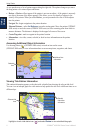
Viewing Current Station Information .............18
Detailed Road and POI Data ........................18
Using Automatic Guidance ............................18
Using Combinations ...............................19
Where To? ...............................................21
Navigating to a Destination ...........................21
Creating and Using Waypoints......................23
Creating and Using Routes ...........................25
Navigating with a Garmin Autopilot ...............26
Viewing Information ...............................27
Viewing Tide Station Information ..................27
Viewing Current Information .........................27
Viewing Celestial Information ........................28
Viewing User Data ........................................28
Viewing the DSC List ....................................30
Viewing Fuel Gauges ....................................31
Viewing Video ...............................................31
Conguring the Chartplotter .................32
Conguring System Settings .........................32
Changing the System Language ...................32
Conguring Navigation Preferences .............32
Conguring Units of Measure .......................33
Conguring Communications Settings ..........33
Setting Alarms ...............................................34
Setting the Total Fuel Onboard Alarm ...........35
Conguring My Boat .....................................35
Conguring Other Vessels ............................36
Using the Garmin Marine Network ........37
Viewing Connected Garmin Marine Network
Devices .......................................................38
Using Radar ............................................39
Using Cruising Mode .....................................40
Using Sentry Mode .......................................40
Radar Targeting ............................................41
Understanding the Radar Overlay Screen ....42
Obtaining Optimal Radar Display
Performance ...............................................42
Adjusting the VRM and EBL..........................43
Conguring Other Vessels on the Radar
Screen ........................................................43
Advanced Radar Conguration .....................44
Using Sonar ............................................45
Understanding the Full Screen .....................45
Understanding the Split Zoom Screen ..........45
Understanding the Split Frequency Screen ..46
Understanding the Temp Log ........................46
Setting Up Sonar ...........................................47
Advanced Sonar Settings .............................48
Digital Selective Calling (DSC) ..............49
Using the Chartplotter with a VHF Radio ......49
Adding a DSC Contact ..................................49
Viewing the DSC List ....................................50
Receiving Distress Calls ...............................50
Man-Overboard Distress Calls Initiated
from a VHF Radio .......................................50
Man-Overboard Distress Calls Initiated
from the Chartplotter ..................................50
Position Tracking ...........................................51
Placing an Individual Routine Call ................52
Calling an AIS Target ....................................52
Appendix .................................................53
Specications ................................................53
Calibrating the Touchscreen .........................54
Capturing Screenshots .................................54
Alarms and Messages ..................................55
Product Registration .....................................57
Contact Garmin .............................................57
Declaration of Conformity (DoC) ...................57
Software License Agreement ........................57
NMEA 0183 and NMEA 2000 ........................58
Index ........................................................59