


36 GPSMAP
®
4000/5000 Series Owner’s Manual
Conguring the Chartplotter
Conguring the
Chartplotter
Safe Height—set the minimum height (chart height datum) of a bridge that your boat can safely
travel under.
Shoreline Distance—set how close you want to travel near the shore: Nearest, Near, Normal,
Far, or Farthest. This is used by the automatic guidance calculation to determine how close
to the shoreline you want the automatic-guidance line to be. Changing this while navigating an
automatic-guidance line will recalculate the path.
Keel Offset—offset the surface reading for the depth of a keel, making it possible to measure depth
from the bottom of the keel instead of from the transducer location. Enter a positive number to offset
for a keel. Enter a negative number to offset for a large vessel that may draw several feet of water.
To adjust the Keel Offset:
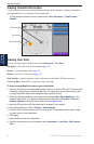
1. From the Home screen, select Congure > My Boat > Keel Offset.
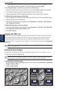
2. Use the ROCKER (GPSMAP 4000 series) or the onscreen keyboard (GPSMAP 5000 series) to
specify the offset.
3. Select Done to accept the number.
NOTE: Select Cancel to cancel your changes and return to the My Boat screen.
Temp Offset—set the temperature offset for the temperature sensor of your transducer.
Calibrate Water Speed—use this menu to calibrate a speed-sensing device. Follow the on-screen
directions for calibration. If you do not have a speed-sensing device, this menu does not appear.
NOTE: If the boat is not moving fast enough or the speed sensor is not registering a speed, a “Speed
Too Low” message appears. Select OK and safely increase boat speed. If you get the message again,
stop the boat and make sure the speed-sensor wheel is not stuck. If the wheel turns freely, check the
cable connections. If you continue to get the message, contact Garmin Product Support.
Fuel Capacity—enter the total fuel capacity of your boat.
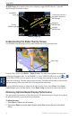
Conguring Other Vessels
To congure settings for boats other than your own, from the Home screen, select Congure >
Other Vessels.
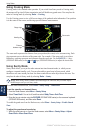
AIS—turn AIS (Automatic Identication System) on or off. AIS alerts you to area trafc by
providing boat IDs, position, course, and speed for boats that are within range and equipped with a
transponder.
DSC—turn DSC (Digital Selective Calling) on or off.
NOTE: To congure AIS or DSC information for other boats, your unit must be connected to an
external AIS or DSC device.
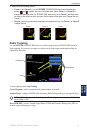
Collision Alarm (AIS and MARPA only)—turn a safe zone around your boat on or off. This is used
for collision avoidance, and can be customized.
To customize safe-zone settings:
From the Home screen, select Congure > Other Vessels > Collision Alarm.
Range—change the measured radius of the safe-zone ring to a specied distance from 500 ft.
to 2.0 nm (or from 150 m to 3.0 km, or from 500 ft. to 2.0 mi).
Time to (Safe Zone)—sounds an alarm if AIS or MARPA determines that a target will intersect
the Safe Zone within the dened time interval (ranging from 1 to 24 minutes).
•
•
•
•