


8 GPSMAP
®
4000/5000 Series Owner’s Manual
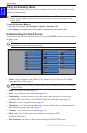
Using Charts
USinG
ChartS
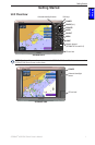
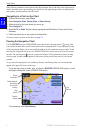
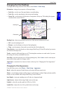
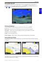
Using Mariner’s Eye
Mariner’s Eye provides a view from above and behind the boat (according to your course), and
provides a visual navigation aid. This view is helpful when navigating tricky shoals, reefs, bridges,
or channels, and is benecial when trying to identify entry routes and exit routes in unfamiliar
harbors or anchorages.
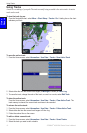
To access the Mariner’s Eye screen, from the Home screen, select Charts > Mariner’s Eye.
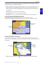
Press the RANGE (+) key (GPSMAP 4000 series) or touch the key (GPSMAP 5000 series) to
move the view closer to your boat and lower to the water. Press the RANGE (-) key (GPSMAP 4000
series) or touch the key (GPSMAP 5000 series) to move the view away from the boat.
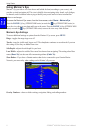
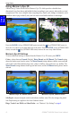
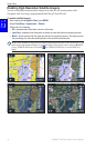
Mariner’s Eye Settings
To access additional settings or options from the Mariner’s Eye screen, press MENU.
Rings—toggles the range rings on or off.
Tracks
—turns the visible track log on or off. The chartplotter continues to record tracks if you turn
this setting off, but they are hidden from view.
Safe Depth—adjusts the safe depth for your boat.
Lane Width—adjusts the width of the course line drawn when navigating. This setting also affects
routes (Route To), but does not affect automatic guidance (Guide To).
Show Radar—
If you have a Garmin marine radar device connected to your Garmin Marine
Network, you can overlay radar readings on the Mariner’s Eye screen.
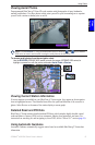
Mariner’s Eye With Radar Information
Overlay Numbers—shows or hides cruising, navigation, shing, and sailing numbers.