


12 GPSMAP
®
4000/5000 Series Owner’s Manual
Using Charts
USinG
ChartS
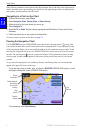
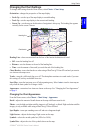
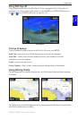
Using Mariner’s Eye 3D
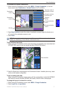
A BlueChart g2 Vision SD card offers Mariner’s Eye 3D, which provides a detailed three-
dimensional view from above and behind the boat (according to your course), and provides a visual
navigation aid. This view is helpful when navigating tricky shoals, reefs, bridges, or channels, and is
benecial when trying to identify entry and exit routes in unfamiliar harbors or anchorages.
Mariner’s Eye 3D Navigation Chart
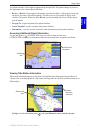
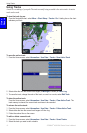
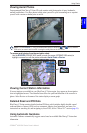
Press the RANGE (+) key (GPSMAP 4000 series) or touch the key (GPSMAP 5000 series) to
move the view closer to your boat and lower to the water. Press the RANGE (-) key (GPSMAP 4000
series) or touch the key (GPSMAP 5000 series) to move the view away from the boat.
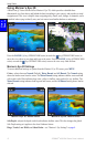
Mariner’s Eye 3D Settings
To access additional settings or options from the Mariner’s Eye 3D screen, press MENU.
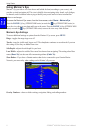
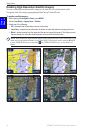
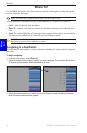
Colors
—selects between Normal (Default), Water Hazard, and All Hazard. The Normal setting
shows the land as seen from the water. The Water Hazard setting indicates shallow water and land
with a color scale. Blue indicates deep water, yellow is shallow water, and red is very shallow. The
Water Hazard setting indicates land in green and brown, and the All Hazard setting shows land as
dark red.
Mariner’s Eye 3D, Normal Colors Mariner’s Eye 3D, Hazard Colors
Safe Depth—adjusts the depth at which red indicates shallow water. This also changes the global
Safe Depth setting as it applies to the Auto Guidance feature.
Rings, Tracks, Lane Width, and Show Radar—see “Mariner’s Eye Settings” on page 8.