


GPSMAP
®
4000/5000 Series Owner’s Manual 5
Using Charts
USinG
ChartS
Using Charts
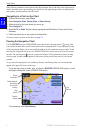
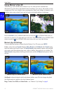
Your unit has a basic worldwide imagery map. By purchasing an optional Blue Chart
®
g2 Vision™
preprogrammed SD card, you can view detailed information for your region, including:
Navigation Chart—displays navigation data, including buoys, lights, cables, depth soundings,
marinas, and tide stations in an overhead view.
Mariner’s Eye and Mariner’s Eye 3D—displays a view from above and behind your boat for a
visual navigation aid.
Fishing Chart—removes navigational data from the chart and enhances bottom contours for
depth recognition.
Fish Eye 3D—an underwater view that visually represents the sea oor according to the
information on the chart.
The unit automatically shows relevant navigational data when you select a navigation option.
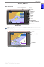
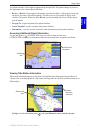
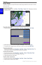
Using the Navigation Chart
Use the Navigation Chart to plan your course, to view map information, and as a navigational aid.
To access the Navigation Chart, from the Home screen, select Charts > Navigation Chart.
Navigation Chart with BlueChart g2 Vision Data
Buoy
Beacon
Your boat
Exposed
wreck
Marine
services
Zoom scale
Submerged
wreck
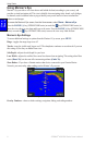
Zooming In and Out on the Map
The RANGE (+/-) keys (GPSMAP 4000 series) or the and keys (GPSMAP 5000 series)
control the zoom level, indicated by the scale at the bottom of the navigation chart ( ). The
bar under the number represents that distance on the map.
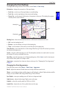
Navigation Chart Settings
To access additional settings or options for the Navigation chart, press or touch MENU.
Overlay Numbers—show or hide cruising, navigation, shing, and sailing numbers on the screen.
Chart Setup—customize the Navigation chart.
Understanding Chart Data
BlueChart g2 and BlueChart g2 Vision charts use graphic symbols to denote map features, which
follow the standards for US and international charts.
•
•
•
•