


50 GPSMAP
®
4000/5000 Series Owner’s Manual
Index
P
panning the navigation chart 6
photos 9, 14, 15
POI data 15
position format 29
position icon 6
POWER key 1
preferred devices 30
product registration 47
R
radar 35–38
antenna size 37
motor speed 37
overlay screen 38
setup 37
range 42
Range keys 1
registration 47
restoring factory settings 3
review 7
rings 8, 37
roads 15
Rocker 1
routes
creating 22
deleting all 26
editing 23
route to 18
S
safe depth 8, 12, 31
safe height 31
safe zone 32
satellite signals 3
scroll speed 41
SD cards
inserting and removing 3
search for a destination by name 19
settings
alarms 30
chart 9
combinations 17
communications 30
sh eye 3D 13
initializing 44
mariner’s eye 8
mariner’s eye 3D 12
navigation chart 5
radar 37
sonar 41
sonar (advanced) 42
system 29
show radar 8
simulator mode 4, 29
soft keys i, 1
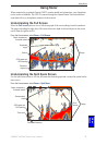
sonar 39–42
a-scope 42
color scheme 41
depth line 42
sh symbols 41
frequency 42
full screen 39
gain 42
range 42
scroll speed 41
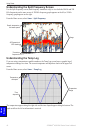
split frequency screen 40
split zoom screen 39
surface noise 41
temp log 40
whiteline 41
zoom 42
sonar cone 13
sonar cone angles 32
specications 43
split frequency screen 40
split zoom screen 39
spot depths 9
stop navigating 19
sun and moon 25
surface noise 41
symbols 9
system information
viewing
3
system settings 29
T
targeting (radar) 37
temp log 40
tide station 7, 24
timed xmit 37
tracks 8, 9, 10, 13
deleting all 26
track up 9
transfer data 26, 33
turn the unit off 2
U
unit ID number
viewing
3
units of measure 29
user data 25
V
video 28
view
system information
3
W
WAAS 29
waypoint 20
create new 20
delete 22
edit existing 21
man overboard 21
mark current location 21
moving 21
waypoints
deleting 21
where to 4, 18–23
whiteline 41
wireless devices 30
X
xtalk reject 37
Z
zoom 5, 42