


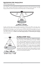
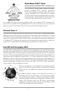
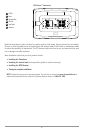
QuadraBeam PLUS™ Sonar
(optional-purchase QuadraBeam PLUS™ transducer only)
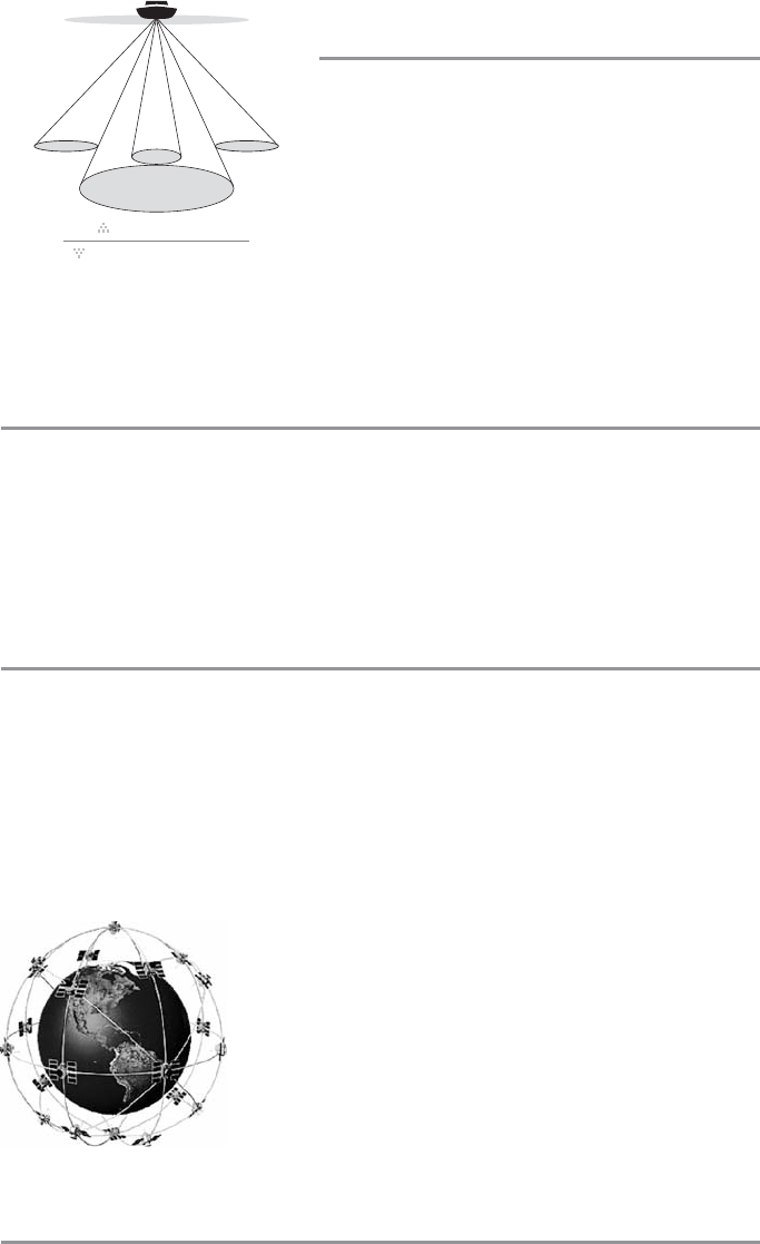
Your 1100 Series™ Fishing System supports the optional-
purchase QuadraBeam PLUS™ transducer. QuadraBeam
PLUS™ sonar provides an extremely wide (90°) area of
coverage. QuadraBeam PLUS™ starts with two fan-shaped
35° 455 kHz Side Structure locating sonar beams to spot fish,
bait and structure to the left and right of the boat over an area
of the bottom that’s always equal to twice your depth.
For a detailed view below the boat, QuadraBeam PLUS™ uses DualBeam PLUS™ technology, with
precision 20° and wide 60° beams. QuadraBeam PLUS™ finds more fish faster, and can even tell you
where to put your bait by showing if fish are to the left, right or directly beneath your boat.
Universal Sonar 2
Your 1100 Series™ Fishing System supports Universal Sonar 2, a state-of-the-art, integrated and protected
transducer that is built into the lower unit of Minn Kota® trolling motors. With Universal Sonar 2, all wiring
is concealed inside the indestructible composite shaft—out of sight and out of harm’s way, with no
clamps, ties, or exposed wires. Universal Sonar 2 features new temperature sensing and the performance
of DualBeam PLUS™ technology. An expanded view and greater bottom detail gives you a totally new
perspective of the water below, along with optimal sonar performance to help you find fish.
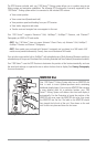
How GPS and Cartography Work
Your 1100 Series™ Fishing System also supports GPS and chartplotting, and uses GPS and sonar to
determine your position, display it on a grid, and provide detailed underwater information. The Global
Positioning System (GPS) is a satellite navigation system designed and maintained by the U.S. Department
of Defense. GPS was originally intended for military use; however, civilians may also take advantage of its
highly accurate position capabilities, typically within +/- 4.5 meters, depending on conditions. This means
that 95% of the time, the GPS receiver will read a location within 4.5 meters of your actual position. Your
GPS Receiver also uses information from WAAS (the Wide Area Augmentation System), EGNOS (the
European Geostationary Navigation Overlay Service), and MSAS (the MTSAT Satellite Augmentation
System) satellites if they are available in your area.
GPS uses a constellation of over 24 satellites that continually send radio
signals to the earth. Your present position is determined by receiving
signals from up to 16 satellites and measuring the distance from the
satellites.
All satellites broadcast a uniquely coded signal once per second at
exactly the same time. The GPS receiver on your boat receives signals
from satellites that are visible to it. Based on time differences between
each received signal, the GPS receiver determines its distance to each
satellite. With distances known, the GPS receiver mathematically
triangulates its own position. With once per second updates, the GPS
receiver then calculates its velocity and bearing.
90° Total Coverage
Bottom Coverage
=
2 x Depth
35° 60° 20° 35°
455 kHz 455 kHz
83 kHz
200 kHz
4