


6
receivers and the GPS navigation system, skip on ahead to Section 2,
Installation & Accessories on page 11. If you're new to GPS, read on, and
you can later impress your friends with your new-found knowledge.)
First, think of your unit as a small but powerful computer. (But don't
worry — we made the series easy to use, so you don't need to be a
computer expert to find your way!) The unit includes a keypad and a
screen with menus so you can tell it what to do. The screen also lets the
unit show your location on a moving map, as well as point the way to
your destination.
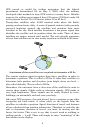
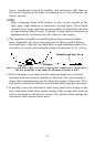
This gimbal-mounted unit uses an external antenna/receiver module,
which makes the whole system work something like your car radio. But
instead of your favorite dance tunes, this receiver tunes in to a couple of
dozen GPS satellites circling the earth. (It will also listen in to the
WAAS satellites in orbit, but more about that in the upcoming segment
introducing you to GPS and WAAS.)
Your unit listens to signals from as many satellites as it can "see" above
the horizon, eliminates the weakest signals, then computes its location
in relation to those satellites. Once it figures its latitude and longitude,
the unit plots that position on the moving map shown on the screen.
The whole process takes place several times a second!
The performance doesn't stop there. Stored in the permanent memory
of every unit is a basic background map of the entire world. We lock it
in here at the factory — you can't change or erase this map.
The background map is suitable for many navigation chores, but for
maximum accuracy and much more detail, you need our optional map-
making software, MapCreate 6. Some unit features — such as
searching for businesses and addresses — won't work without a custom
MapCreate map. There is so much detail in our background map (and
even more in MapCreate) that we'll describe its contents and
differences in Section 6, Basic GPS Operations, on page 89.
Another portion of the unit's onboard memory is devoted to recording
GPS navigation information, which includes waypoints, event marker
icons, trails and routes. This lets you look back the way you came. Think
of this data storage like the hard drive memory in a computer or a tape
in a cassette tape recorder. You can save several different GPS data files,
erase 'em and record new ones, over and over again. Like any computer
file, these GPS Data Files (file format *.usr) can be shared between
other Eagle GPS or sonar/GPS units and even personal computers.
Your unit has one more thing in common with a personal computer.
Just as computers have a floppy disk drive for storing and exchanging