


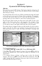
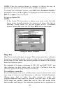
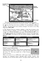
137
navigation begins. Press
EXIT to clear the alarm.) When navigation
starts, press ↑ to increase speed to the desired setting.
4. Press
EXIT to turn off the steering and speed boxes. The unit will now
automatically "steer" along the trail or route. When you arrive at your
"destination," cancel navigation.
Tip:
You can pick any spot on the map to begin your simulation by using
the Initialize GPS command.
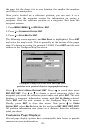
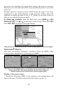
Hide GPS Features
If there is no GPS antenna/receiver module attached to this unit, the
GPS menus and features can be hidden from view with this command.
The default setting is off, allowing you to rotate between the Sonar
Page and the GPS pages. To hide GPS features:
Press
MENU|MENU|↓ to SYSTEM SETUP|ENT|↓ to HIDE GPS FEATURES|ENT.
The GPS menus and pages are now hidden.
To restore
GPS FEATURES, press MENU|MENU|↓ to SHOW GPS
FEATURES|ENT. The GPS menus and pages are available once again.
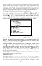
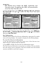
Initialize GPS
This command makes the unit operate as if it is sitting someplace other
than its actual location. So, you and your unit could be located in
Kansas City, but practice navigating in the ocean off Islamorada,
Florida.
1. With the GPS simulator off, press
MENU|MENU|↓ to GPS
SETUP|ENT|ENT.
2. A message appears, telling you to move the cursor near the desired
location and press
ENT. When the message automatically clears, follow
the message instructions. Turn on the GPS Simulator.
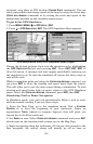
3. In a moment, your present position marker arrow appears on the
map in the location you selected with the cursor. The unit will consider
that spot as its last known position until changed by either a live
satellite lock-on or a new simulator location.
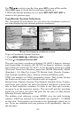
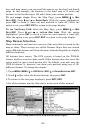
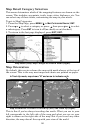
Map Auto Zoom
This receiver has an auto zoom feature that eliminates a lot of the
button-pushing characteristics of other brands of GPS receivers. It
works in conjunction with the navigation features.
First, start navigating to a waypoint. (See the waypoint section for
more information on navigating to a waypoint.) With auto zoom on, the
unit zooms out until the entire course shows, from the present position
to the destination waypoint.