


140
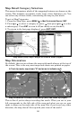
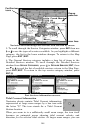
keys and map cursor, you can scroll the map to see the third and fourth
rings. In this example, the distance to the third ring is 75 miles and
distance to the fourth ring is 100 miles from your current position.
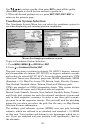
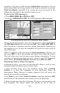
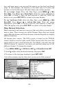
To set range rings: From the Map Page, press
MENU|↓ to MAP
DATA|ENT. Press ↓ and → to RANGE RINGS. With the option highlighted,
press
ENT to check it (turn on) and uncheck it (turn off.) After the
option is set, press
EXIT|EXIT to return to the page display.
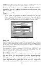
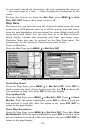
To set Lat/Long Grid: From the Map Page, press
MENU|↓ to MAP
DATA|ENT. Press ↓ and → to LAT/LON GRID LINES. With the option
highlighted, press
ENT to check it (turn on) and uncheck it (turn off.)
After the option is set, press
EXIT|EXIT to return to the page display.
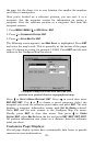
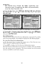
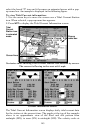
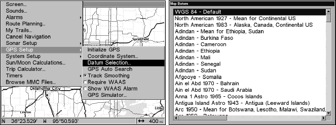
Map Datum Selection
Maps and charts are based on a survey of the area that's covered by the
map or chart. These surveys are called Datums. Maps that are created
using different datums will show the same latitude/longitude in slightly
different locations.
All datums have names. The GPS system is based on the WGS-84
datum, which covers the entire world. Other datums may also cover the
entire world or just a small portion of it. By default, your unit uses the
WGS-84 datum. It, however, can show your position using any of 191
different datums. To change the datum:
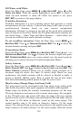
1. Press
MENU|MENU|↓ to GPS SETUP|ENT|↓ to DATUM SELECTION|ENT.
2. Scroll ↓ or ↑ to select the desired datum, then press ENT.
3.
To return to the last page displayed, press EXIT|EXIT.
A list of the datums used by this unit is in the back of this manual.
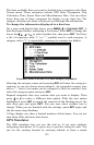
GPS Setup Menu (left); Map Datum Menu (right).