


134
the map, but the closer it is to your location, the smaller the numbers
you'll have to manipulate.
Once you've decided on a reference position, you can save it as a
waypoint. See the waypoint section for information on saving a
waypoint. Save the reference position as a waypoint. Exit from the
waypoint screens.
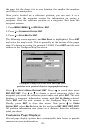
1. Press
MENU|MENU|↓ to GPS SETUP|ENT.
2. Press ↓ to
COORDINATE SYSTEM|ENT.
3. Press ↓ to
SETUP MAP FIX|ENT.
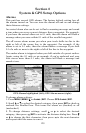
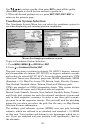
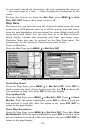
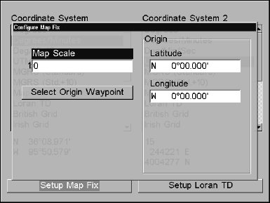
The following screen appears, and
MAP SCALE is highlighted. Press ENT
and enter the map's scale. This is generally at the bottom of the paper
map. It's shown as a ratio, for example 1:24000. Press
EXIT and the unit
returns to the Configure Map Fix screen.
Configure a map fix so the unit can find your
position on a printed chart or topographical map.
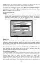
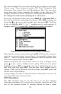
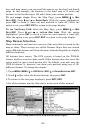
Press ↓ to SELECT ORIGIN WAYPOINT|ENT. Press → to saved then press
ENT|ENT|ENT. Use ↓ or ↑ to choose a saved waypoint. Select the
waypoint you saved the reference point under and press
ENT. The unit
displays a waypoint information screen with
SET AS ORIGIN selected.
Press
ENT and the unit returns to the Configure Map Fix menu.
Finally, press
EXIT to close this menu. Now press ↑ to COORD
SYSTEM|ENT, select MAP FIX from the list and press ENT|EXIT|EXIT|EXIT.
All position information now shows as a distance from the reference
point you chose.
Customize Page Displays
Several page display options have customizable data boxes to provide
constant on-screen information.