


7
files, this unit has a slot for an MMC (MultiMedia Card) or SDC
(Secure Digital card) flash memory card. These solid-state memory
devices are about the size of a postage stamp, but can hold data ranging
from 8 MB to 1 GB in size. (Compare that to a floppy disk's 1.44 MB
capacity!) The unit uses all that MMC space for two key GPS purposes.
(The MMC is also used to record sonar logs. See page 5
First, you can backup your onboard GPS Data Files by copying them to
the MMC. Since the MMC is removable (like a floppy disk or a cassette
tape), you can store these GPS Data Files on a personal computer
equipped with an MMC card reader. (Or store them on a pocketful of
MMCs, if you don't have a computer.) Our MapCreate mapping software
can save, edit or create its own GPS Data Files, which can be copied to
the MMC and then loaded from the MMC into the unit's memory.
(NOTE: No matter where they come from, GPS Data Files must be
loaded from the MMC into memory before the unit can use them.)
The other key GPS use for MMCs is storage of special high-detail,
custom maps, which you can produce on your computer with our
MapCreate software. These MapCreate custom maps contain much
greater detail than the basic background map. These Custom Map
Files (file format *.lcm) can also be shared between other Eagle GPS or
sonar/GPS units and personal computers. (For example, the exact same
MMC, custom map files and GPS data files can be used
interchangeably between your gimbal-mounted unit and the hand-held
iFINDER GPS receiver.)
The unit automatically reads Custom Map Files directly from the MMC
or SD card. To use a custom map, all you need to do is slide an MMC
containing a map into the unit.
Introduction to GPS and WAAS
Well, now you know the basics of how the unit does its work. You might
be ready to jump ahead to Section 2, Installation & Accessories, on page
11, so you can mount your unit and plug in the power. Or you might
want to see how our text formatting makes the manual tutorials easy to
skim. If that's the case, move on to "How to Use This Manual" on page
9. But, if you want to understand the current state of satellite
navigation, look over this segment describing how GPS and its new
companion WAAS work together to get you where you're going.
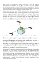
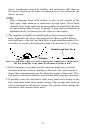
The Global Positioning System (GPS) was launched July 17, 1995 by
the United States Department of Defense. It was designed as a 24-
hour-a-day, 365-days-a-year, all weather global navigation system for
the armed forces of the U.S. and its allies. Civilian use was also
available, but it was less accurate because the military scrambled the
signal somewhat, using a process called Selective Availability (SA.)