


1–4
1.5 Selecting Chart Scale
Press the [ZOOM IN] or [ZOOM OUT] key to select suitable chart
scale. Display range appears at the center of the display momen-
tarily when the zoom keys are pressed.
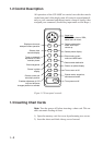
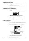
1.6 Adjusting Tone and Brilliance
1) Press the [TONE] key. The tone and brilliance setting display
appears.
LOW HIGH
LOW HIGH
TONE: 5
BRILL: 3
Figure 1-5 Tone and display brilliance setting display
2) Operate the [t] or [s] key to adjust display tone.
3) Press the [▲] or [▼] key to adjust display brilliance.
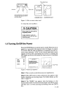
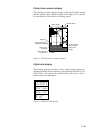
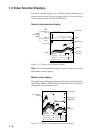
1.7 Plotter Displays
The [PLTR] key selects a plotter display among normal plotter,
plotter/video sounder, data, graphic and highway.
Normal plotter display (North-up presentation)
WP001 120° 223.8nm
CSE 180° SPD 16.8kt 3D
DEP 113.6 ft TMP 16.0°C 12.0V
POS 34°26.345'N 135°41.232'E
L
L
Own ship mark
Course bar
Track
Chart icon
Range and bearing to
destination waypoint
Ship's course
and speed
Depth and water
temperature
Position
Receive mode or
alarm message
Ship's mains
voltage
Figure 1-6 Plotter display, north-up presentation
Note: The presentation mode on the plotter displays is selected by
the [NU/CU ENT] key. See page 2-2.