


5–1
5. MENU OPERATIONS
5.1 Chart Position Calibration
In some instances chart position may be off by a few minutes. For
example, the position of the ship is shown to be at sea while it is in
fact moored at a pier. You can compensate for this error as follows.
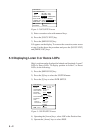
1) Press the [MENU ESC] key.
2) Press the [0] key to select SYSTEM SETUP.
3) Press the [9] key to select CHART POSN CALIB.
4) Press the [s] key to select ON.
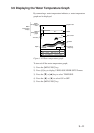
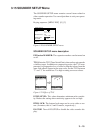
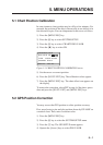
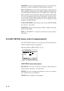
CHART POSN CALIB
POSN CALIB OFF ON
CALIB 00.000'N 00.000'E
GEODETIC WGS-84
ENT : Ent ESC : Esc
Figure 5-1 CHART POSITION CALIBRATION menu
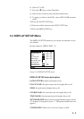
5) Set the cursor on correct position.
6) Press the [NU/CU ENT] key. The calibration values appear.
7) Press the [MENU ESC] key. The chart offset icon appears on
the display.
To remove the correction, select OFF in step 4 of the above proce-
dure and press the [NU/CU ENT] and [MENU ESC] keys.
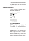
5.2 GPS Position Correction
You may correct the GPS position to refine position accuracy.
First, moor boat at a pier and plot position shown by GP-1600F on
a nautical chart. Then, enter correction value.
1) Press the [MENU ESC] key.
2) Press the [0] key to select the SYSTEM SETUP menu.
3) Press the [7] key. The GPS SETUP menu appears.
4) Operate the [Arrow] keys to select POS CALIB.