


2–1
2. PLOTTER OPERATION
2.1 Plotter Displays
The plotter display traces the ship’s track on the display using po-
sition data fed from the GPS navigator. The track is continuously
plotted, even when viewing the video sounder display.
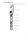
Selecting plotter displays
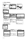
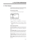
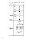
1) Press the [PLTR] key. The following menu appears.
SELECT PLOTTER MODE
▲
▼
Plotter
Plotter/Sounder
Data
Graphic
Highway
PLTR:Sel ESC:Close
Figure 2-1 Plotter display selection menu
2) Press the [PLTR] key or the [▲]/[▼] key to select display de-
sired.
3) Press the [MENU ESC] key. The menu disappears. When the
[MENU ESC] key is not pressed, the menu disappears after 10
seconds.
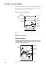
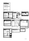
Plotter display description
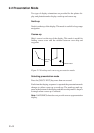
Normal plotter display: This display traces the ship’s track on
the screen. Coastline charts, provided on chart cards (option), dis-
play the coastline of your area. Navigation data is digitally dis-
played.
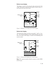
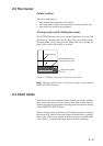
Plotter/Sounder display: This display provides the plotter dis-
play on the left 3/4 of the screen and video sounder picture on the
right 1/4. It is useful for monitoring the seabed while cruising.
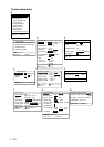
Digital data display: This display provides digital navigation data.
Graphic data display: This display provides navigation data in
graphic form. Own ship's direction and drift are graphically shown.
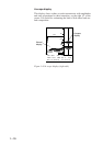
Highway display: The highway display provides a 3D view of
ship's courseline forward of own ship. It is useful observing cross
track error.