


iii
TABLE OF CONTENTS
FOREWORD ............................................. v
1. OPERATIONAL OVERVIEW
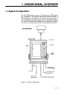
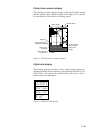
1.1 System Configuration ....................... 1-1
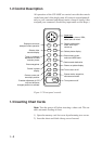
1.2 Control Description .......................... 1-2
1.3 Inserting Chart Cards ........................ 1-2
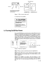
1.4 Turning On/Off the Power ................ 1-3
1.5 Selecting Chart Scale ........................ 1-4
1.6 Adjusting Tone and Brilliance .......... 1-4
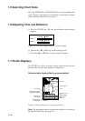
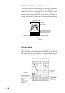
1.7 Plotter Displays ................................. 1-4
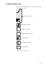
1.8 Plotter Display Icons ........................ 1-7
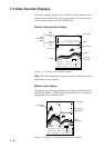
1.9 Video Sounder Displays ................... 1-8
1.10 Menu Operation ............................ 1-11
1.11 Menu Displays .............................. 1-12
2. PLOTTER OPERATION
2.1 Plotter Displays ................................. 2-1
2.2 Presentation Mode ............................ 2-2
2.3 The Cursor ........................................ 2-3
2.4 Chart Cards ....................................... 2-3
2.5 Chart Symbols .................................. 2-5
2.6 Shifting the Plotter Display .............. 2-7
2.7 Entering Waypoints........................... 2-8
2.8 Changing Waypoint Data ................ 2-12
2.9 Erasing Waypoints .......................... 2-13
2.10 Setting/Canceling Destination
Waypoint ....................................... 2-13
2.11 Entering Routes............................. 2-15
2.12 Setting Trial Speed........................ 2-18
2.13 Following a Route ........................ 2-19
2.14 Skipping/Restoring Route
Waypoints ..................................... 2-20
2.15 Cancelling Route Navigation ........ 2-20
2.16 Erasing Route Waypoints.............. 2-20
2.17 Entering Marks ............................. 2-21
2.18 Changing Mark Attributes ............ 2-22
2.19 Erasing Marks ............................... 2-23
2.20 Connecting Marks......................... 2-23
2.21 Entering Event Marks ................... 2-24
2.22 Erasing Event Marks .................... 2-25
2.23 Setting Event Position as
Destination .................................... 2-25
2.24 Changing Event Mark Shape ........ 2-25
2.25 The MOB Function ....................... 2-25
2.26 Stopping Plotting of Track ............ 2-26
2.27 Changing Track Plotting Interval.. 2-27
2.28 Erasing All Track, Marks .............. 2-27
3. VIDEO SOUNDER
OPERATION
3.1 Principle of Operation....................... 3-1
3.2 Video Sounder Displays ................... 3-2
3.3 Automatic Video Sounder Operation 3-6
3.4 Manual Video Sounder Operation .... 3-7
3.5 Suppressing Low Level Noise .......... 3-8
3.6 Selecting Picture Advance Speed ..... 3-9
3.7 Suppressing Interference ................ 3-10
3.8 Knowing Depth Change by Depth
Alert Alarm ..................................... 3-10
3.9 Displaying the Water Temperature
Graph .............................................. 3-11
3.10 Brightening Fish Echoes ............... 3-12
3.11 Selecting Zoom Ratio ................... 3-12
3.12 Measuring Depth by the VRM ..... 3-13
3.13 Fish and Bottom Alarms ............... 3-13
3.14 Correcting Water Temperature
Readout ......................................... 3-14
3.15 SOUNDER SETUP Menu ............ 3-15
4. ALARMS
4.1 Description of Alarms ....................... 4-1
4.2 Enabling/Disabling the Alarms ......... 4-2
4.3 Deleting Aural and Visual Alarms .... 4-3
5. MENU OPERATIONS
5.1 Chart Position Calibration ................ 5-1
5.2 GPS Position Correction ................... 5-1
5.3 Displaying Loran C or Decca LOPs . 5-2
5.4 DISPLAY SETUP Menu .................. 5-3
5.5 PLOTTER SETUP Menu ................. 5-4
5.6 UNIT SETUP menu
(unit of measurement) ....................... 5-6
5.7 SENSOR SETUP menu .................... 5-7
5.8 NMEA SETUP menu ........................ 5-7
5.9 GPS SETUP menu ............................ 5-8
5.10 DGPS SETUP Menu ..................... 5-10