


2–3
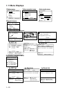
2.3 The Cursor
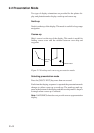
Cursor function
The cursor functions to
• find latitude and longitude of a location
• find range and bearing from your ship to cursor position, and
• enter and erase marks and waypoints.
Turning cursor on/off, shifting the cursor
The [CURS] key turns the cursor on/off alternately. You can shift
the cursor by operating the [Arrow] keys. The cursor moves in the
direction of the [Arrow] key pressed. When the cursor reaches an
edge of the screen, the display is scrolled.
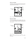
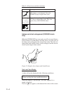
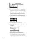
Latitude and longitude
of cursor
Range and bearing from
current position to cursor
Cursor(large size)
WP001 120° 223.8nm
BRG
+
331.1°
RNG
+
12.3nm 2D
DEP 113.6 ft TMP 16.0°C 12.0V
CUR 34°26.345'N 135°41.232'E
Figure 2-3 Display, showing location of cursor data
Note: The size of the cursor can be set for large or small on the
DISPLAY SETUP menu.
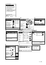
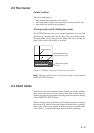
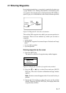
2.4 Chart Cards
The chart cards contain nautical charts. When you insert a suitable
chart card in the drive and your boat is near land, a chart appears
with the land portion arranged according to the land pattern setting
on the DISPLAY SETUP menu.
When a wrong card is inserted or the wrong chart scale is selected,
the land will be hollow. Insert the proper card and select a suitable
chart scale. Chart icons appear to help you select suitable chart
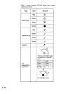
scale. Table 2-1 explains the chart icons and their meanings.