


2 – 26
2.27 Changing Track Plotting Interval
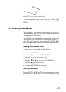
In drawing the track, first the ship’s position (fed from the GPS
navigator) is stored into this unit’s memory at an interval of time,
distance or automatic recording. A shorter interval provides better
reconstruction of the track, but the storage time of the track is re-
duced. When the track memory becomes full, the oldest track is
erased to make room for the latest.
1) Press the [MENU ESC] key.
2) Press the [2] key to select TRACK/MARK SETUP.
3) Operate the [Arrow] keys to select AUTO, TIME or DIST on
the PLOT INTVL line. DIST plots ship’s track only when the
boat is moving, thus no track is saved to the memory when
your boat is dead in water. AUTO changes with chart scale
automatically.
4) For time or distance, enter interval.
5) Press the [MENU ESC] key to close the menu.
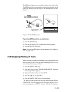
2.28 Erasing All Track, Marks
You can erase all track and marks (except MOB mark) as follows:
1) Press the [MENU ESC] key.
2) Press the [3] key to select ERASE TRACK/MARK.
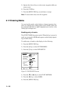
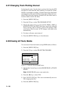
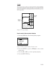
ERASE TRACK/MARK
MARK ERASE NO YES
TRACK ERASE NO YES
MARK USED 0/100 PT
TRACK USED 0/2000 PT
▲▼:Cursor :Go ESC:Esc
Figure 2-27 ERASE TRACK/MARK menu
3) Operate the [Arrow] keys to select MARK ERASE or TRACK
ERASE.
Note: MARK ERASE erases event marks also.
4) Press the [s] key to select YES.
5) Press [NU/CU ENT] key. The cursor automatically moves to
NO on appropriate line.
6) Press the [MENU ESC] key.