


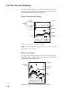

1–6
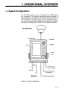
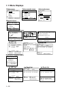
Graphic data display, autopilot connection
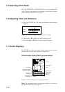
This display provides position, range and bearing to destination
waypoint, trip distance, Estimated Time of Arrival (ETA) at desti-
nation, Time-To-Go to destination (TTG), and XTE scale, which
shows the amount (in nautical miles) and direction to steer to re-
turn to intended course. The XTE scale in Figure 1-9 shows you
should steer right by 0.3 nautical miles to return to intended course.
POS
34° 26.345°N 135° 38.417' E
S
W
BRG
248°
CSE
323°
1nm
1nm
TRIP
RNG
ETA
TTG
789
nm
1123
nm
23: 20
'
14
H
20
M
Own ship's position
XTE (amount in nautical miles
boat is off course and amount
to steer to return to intended
course)
Time-to-Go to
destination
Estimated Time of
Arrival at destination
Ship's course
Trip distance
Range to destination
waypoint
Bearing to destination
waypoint
Figure 1-9 Graphic data display, with autopilot connection
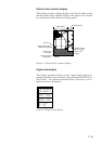
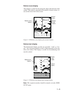
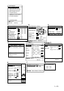
Highway display
The highway shows graphic presentation of ship's cross track error
(XTE). The scale can be changed by the [ZOOM IN] or [ZOOM
OUT] key. The width of the "highway" is changed by the setting of
the XTE alarm (page 4-2).
Figure 1-10 Highway display