


2-7
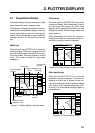
How to read the XTE scale
The black boat-shaped mark shows own
boat’s movement and direction, and amount
to steer to return to course. Using Figure 2-
13 as an example, you would steer right by
000.02 nautical miles to return to course.
When this mark is out of range of the XTE
scale, the mark color changes from black to
yellow. The range of the XTE scale can be
set as shown below (default: 0.5 nm).
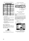
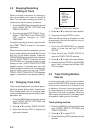
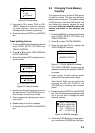
Setting the range of the XTE scale
1. Press the soft key EDIT XT-LMT to dis-
play the following window.
EDIT XTE LIMIT
0 .1nm
Figure 2-14 XTE range setting window
2. Use the cursor pad to select digit to
change.
3. Press appropriate alphanumeric key.
4. Repeat steps 2 and 3.
5. Press the [ENTER] key. To cancel entry,
press the soft key CANCEL.
Note that all digits may be cleared by press-
ing the [CLEAR] key.
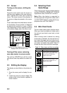
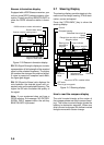
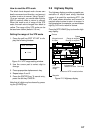
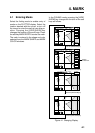
2.8 Highway Display
The highway display provides a graphic pre-
sentation of ship’s track along intended
course. It is useful for monitoring XTE - the
XTE scale shows direction and amount in
nautical miles to steer to return to course. In
the figure below, for example, you would steer
right by 0.02 nm to return to course.
Press the [XTE/HIWAY] key to show the high-
way display.
DGPS 3D
EDIT
XT- LMT
XTE 0.02nm
0.1NM0.1NM
HIGHWAY
001WPT
BRG
RNG
SPD
CSE 87.8
94.6°
1.88nm
10.0 kt
WPT001
YUUKI
FISH01
Amount of XTE in nautical miles
Waypoint mark
& name
Waypoint
Own ship
XTE
indication
range
Bearing to waypoint
Course
Range to waypoint
Speed
Indicates the
direction to steer
Figure 2-15 Highway display