


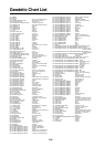
SP - 1
SPECIFICATIONS OF
COLOR GPS/ PLOTTER: GP-1850
COLOR DGPS/ PLOTTER: GP-1850D
1. GENERAL
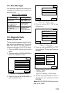
(1) Display 6.5 inch high resolution color LCD
(2) Projection Mercator
(3) Usable Area 85° latitude or below
(4) Display Mode Plotter, Video pilot, Highway display, Waypoint display
(5) Alarms Arrival and Anchor watch, Cross track error and proximity alarms,
Ship’s speed in and out alarms
2. GPS RECEIVER
(1) Receiving Channels 12 channels parallel, 12 satellite tracking
(2) Rx Frequency 1575.42 MHz
(3) Rx Code C/A code
(4) Position Fixing System All in view, 8-state Kalman filter
(5) Position Accuracy Approx. 10 m, 95% of the time,
horizontal dilution of position (HDOP)
≤1
Note: All GPS receiver are subject to degradation of position and
velocity accuracy under the U.S. Department of Defense.
Position may be degraded.
DGPS: approx. less than 5 m, 95% of the time
(6) Tracking Velocity 900 kts
(7) Position-fixing Time Warm start: 12 seconds, Cold start: 90 seconds
(8) Position Update Interval 1 second
(9) DGPS Data Receiving RTCM SC-104 Ver 2.1 formatted
(External DGPS data required for GP-1850)
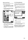
3. DISPLAY SECTION
(1) Effective area 133.4
×97.3 mm
(2) Display pixels 234
×320 dots
(3) Position Indication Latitude/longitude or Loran C LOP or DECCA LOP
4. PLOTTER
(1) Effective Projection Area 0.125 nm to 2,048 nm (at equatorial area)
(2) Track Display Plot interval: by time (0 to 99 min. 59 sec.) or
by distance (0 to 99.99 nm)
(3) Colors Red, yellow, green , purple, light-blue, blue, white