


11-1
11. USING C-MAP NT MODEL
The GP-1850D/1850 C-MAP NT series uses
FURUNO mini chart card and C-MAP NT-FP
chart card. These charts show accurate
coastlines, depth contours, place names, aids
to navigation such as buoys and lighthouses,
and other navigational marks.
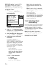
11.1 Inserting Chart Card
Insert an appropriate chart card before
turning on the power.
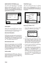
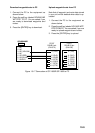
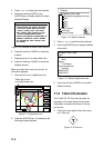
1. Push down the lid catch to open the chart
card slot cover.
Card slot
Figure 11-1 Location of chart card slot cover
2. Insert appropriate chart card groove side
up.
3. Close the slot cover to protect the chart
drive. (Keep the slot cover closed at all
times.)
Note1: Turn off the power before inserting or
ejecting the chart card.
Note2: When using C-MAP NT-FP card, do
not eject it while a chart is being drawn. This
may cause the equipment to stop working.
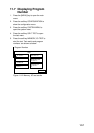
11.2 Cursor and Data
Display
Besides its fundamental functions of
providing position data, the cursor can also
show caution area, depth area, source of
data, etc. Further, you can display information
about an icon by placing the cursor on it.
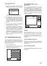
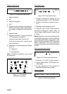
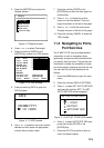
1. Press the cursor pad to turn the cursor
on.
DGPS 3D
CENTER
GO TO
CURSOR
COURSE
UP
ZOOM
OUT
ZOOM
IN
NORTH
UP
135° 12.345' E
34° 12.345' N
OS
FROM
276.9°
16.45nm
Figure 11-2 Plotter display
2. Use the cursor pad to place the cursor on
the position desired.
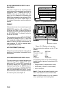
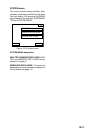
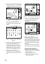
3. Press the [ENTER] key to open the
Objects window. For example the
following window appears.
Objects
Depth area
Source of data
Caution area
Figure 11-3 Objects window