


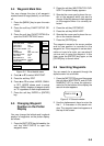


5-3
Changing waypoint name, comment,
proximity alarm radius
1. If necessary, you can change the name
(1 to 6 characters), comment (13 charac-
ters), L/L position and the proximity alarm
radius (explained in detail in Chapter 8)
as follows:
a) Select the NAME, COMMENT or
PROXIMITY ALARM RADIUS field.
b) Use the cursor pad to select charac-
ter or digit.
c) Enter appropriate data with the alpha-
numeric keys.
Note: You cannot change shape and color
of a waypoint when it has a proximity alarm
radius entered. To change shape or color,
enter all zeroes as the proximity alarm ra-
dius.
Changing waypoint position
1. Use the cursor pad to place the cursor in
the LAT LON field.
2. Operate the cursor pad to place the cur-
sor on digit to change. Enter appropriate
data with the alphanumeric keys.
3. You can switch co-ordinates with the soft
key N<-->S/E<-->W.
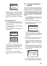
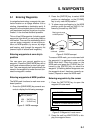
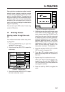
Entering waypoints by range and
bearing
This method is useful when you want to en-
ter a waypoint using range and bearing to a
target found on a radar.
1. Press the [WPT/RTE] key to open the
waypoint & route menu.
2. Press the soft key WAYPOINTS to open
the waypoint menu.
3. Press the soft key WAYPOINT BY
RANGE & BEARING. The plotter screen
appears.
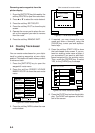
DGPS 3D
RETURN
NEW
WPT
ZOOM
OUT
ZOOM
IN
WPT
RNG BRG
135° 12.345’ E
34° 12.345’ N
’X’
FROM
224.1
0.01nm
START
POINT
X
Figure 5-8 Plotter display, Range and
bearing selected as waypoint entry method
4. Operate the cursor pad to place the cur-
sor on the location desired. The range and
bearing from own ship to cursor appear
at the top of the screen.
Note: The origin point of range and
bearing can be shifted to the place you
desire. Operate the cursor pad to select
location, and then press the soft key
START POINT. “X” appears at the cursor
position.
5. Press the soft key NEW WPT. The screen
should look something like the one shown
in Figure 5-5.
6. If necessary, change data as you did in
“Entering waypoints by the cursor.”
7. Press the soft key SAVE to register the
waypoint.
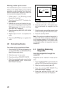
Entering waypoints by latitude and
longitude position
1. Press the [WPT/RTE] key to open the
waypoint & route menu.
2. Press the soft key WAYPOINTS to open
the waypoint menu.
3. Press the soft key LOCAL LIST (lists
waypoints in order from nearest to fur-
thest) or ALPHA/NUMERIC LIST (lists
waypoints in alphanumeric order).