


10-2
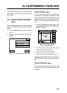
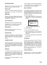
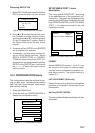
CHART DETAILS menu
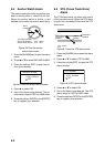
1. Press the [MENU] key followed by the soft
keys CHART SETUP OPTIONS and
CHART DETAILS.
DGPS 3D
CHART
DETAIL
RETURN
EDIT
DEPTH
INFO
LAT/LON GRID
TEXT INFO
WAYPOINT
WAYPOINT NAME
INDEX
LANDMASS
BACKGROUND
NAV AIDS
SECTOR INFO
OTHER SYMBOLS
GREEN
ON
LARGE
ON
ON
BRT YELLOW
BLUE
ON
OFF
WHITE
s
Figure 10-3 Chart details menu
2. Use the cursor pad to select item and
press the soft key EDIT.
3. Select option with cursor pad and press
the soft key RETURN to finish.
Chart details menu description
LAT/LONG GRID: Turns lat/long grid on/off
and changes its color. The default settings
are ON and green.
TEXT INFO: Turns geographic name display
on/off. The default setting is ON.
WAYPOINT: Turns waypoint on or off and se-
lects size to large or small. “LARGE” displays
waypoint in shape selected; “SMALL” shows
waypoints as an X regardless of actual shape.
“OFF” only display waypoints when they are
used in navigation. The default setting is
LARGE.
WAYPOINT NAME: Turns waypoint name
on/off. The default setting is ON.
INDEX: Turns chart indices on/off. The de-
fault setting is ON.
LANDMASS: Selects brightness and color
of landmass. The default settings are bright
and yellow.
BACKGROUND: Select background color to
black or blue (default setting).
NAV AIDS: Turns aids to navigation symbols
(for example, buoys) on/off. The default set-
ting is ON. When OFF is selected, symbols
are displayed and information is not.
SECTOR INFO: Turns lighthouse viewable
angle indication on FURUNO charts on/off.
Viewing angle is shown as an arc extending
from lighthouse position. Arc color, white or
green, is the color of the light beam. This fea-
ture is available with selected charts. The
default setting is ON.
OTHER SYMBOLS: Selects color of all other
chart symbols. The default setting is white.
DEPTH INFO soft key: Turns depth info dis-
play on/off and sets it color.
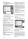
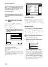
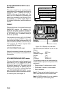
10.2 DISPLAY OPTIONS menu
This menu contains items for setting up the
plotter display.
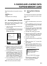
1. Press the [MENU] key.
2. Press the soft key DISPLAY OPTIONS.
The display setup1 menu appears.
DGPS 3D
DISPLAY
SETUP
RETURN
EDIT
RNG & BRG MODE
RANGE/SPEED UNIT
DEPTH UNIT
TEMP UNIT
LAT/LON DISPLAY
TIME DISPLAY
WAYPOINTS SW
COURSE VECTOR
BEARING
MAG VARIATION
TD DISPLAY
POSITION DISPLAY
SET GO TO METHOD
RHUMB LINE
nm / kt
m
°C
DD°MM.MMM'
24 HOUR
AUTO2
LINE
MAGNETIC
AUTO 01.3°E
LORAN C
LAT/LON
1 POINT
s
Figure 10-4 Display setup menu
Display setup menu description
RNG & BRG MODE
The GPS receiver calculates the range, bear-
ing, cross track error (XTE) and ETA to TO
waypoint when you set a destination. The
range and bearing can be calculated by
GREAT CIRCLE (straight line between two
points) or RHUMB LINE (straight line be-
tween two points on nautical chart, default
setting) method.