


iv
A Word to GP-1850D/1850
Owners
Congratulations on your choice of the
FURUNO GP-1850D COLOR DGPS/PLOT-
TER, GP-1850 COLOR GPS/PLOTTER. We
are confident you will see why the FURUNO
name has become synonymous with quality
and reliability.
For over 50 years FURUNO Electric Com-
pany has enjoyed an enviable reputation for
innovative and dependable marine electron-
ics equipment. This dedication to excellence
is furthered by our extensive global network
of agents and dealers.
This equipment is designed and constructed
to meet the rigorous demands of the marine
environment. However, no machine can per-
form its intended function unless installed, op-
erated and maintained properly. Please
carefully read and follow the recommended
procedures for operation and maintenance.
We would appreciate hearing from you, the
end-user, about whether we are achieving our
purposes.
Thank you for considering and purchasing
FURUNO equipment.
FOREWORD
Features
The GP-1850D is a totally integrated DGPS
beacon receiver, GPS receiver, and color
video plotter. The GP-1850 mostly shares the
same features with the GP-1850D except it
does not have a built-in DGPS beacon re-
ceiver.
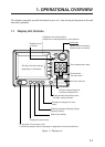
Navigation information is displayed on a
bright 6.5-inch color TFT LCD. On-screen in-
formation shown are position, range and
bearing to cursor position, range, bearing,
ETA and TTG to waypoint, etc.
A high sensitivity receiver tracks up to twelve
satellites simultaneously. An 8-state Kalman
filter ensures optimum accuracy in determi-
nation of vessel position, course and speed.
C-MAP NT-FP chart card is available for the
GP-1850/1850D C-MAP NT.
The main features of the GP-1850D/GP-1850
are
• Comprehensive navigation data displays.
• Bright 6.5-inch color TFT LCD with tem-
perature compensated tone and brilliance
control.
• Automatic coastline chart loading.
• Position display in latitude and longitude,
Loran C or Decca TDs.
• Improved position accuracy with optional
DGPS beacon receiver (GP-1850).
• Accepts both FURUNO and NAVIONICS
or C-MAP NT mini chart cards.
• Alarms: Arrival, Anchor Watch, Cross-track
Error, Speed, Proximity.
• Man overboard feature records latitude
and longitude coordinates at time of man
overboard.
• “Highway” display provides graphic pre-
sentation of ship’s track and is useful for
monitoring cross track error.