


11-3
2. Press the [ENTER] key to open the
Objects window.
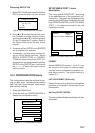
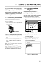
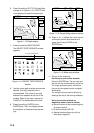
Objects
Depth contour
Caution area
Depth area
Source of data
Tide height
Figure 11-9 Objects window
3. Press or to select Tide height.
4. Press the soft key ENTER or the
[ENTER] key to open the TIDE window.
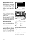
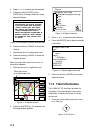
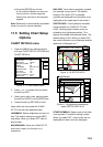
Time: 12:00
Height: 1.21 ft
Draught: 0.82 ft
01/01/00 +01
59 26. 467' N
010 28. 646' E
Port Info
HORTEN
High Water (max) 1.32 ft (13:15)
Low Water (min) 0.32 ft (21:45)
Sunrise 09:15L Sunset 15:27L
0 4 8 12 16 20 24
1.32
1.07
0.82
0.57
0.32
Figure 11-10 TIDE window
5. Press the soft key DATE to open the
DATE window.
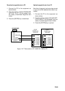
DATE
DD/MM/YYYY
01 / 01 / 2000
Figure 11-11 DATE window
6. Use or to position the cursor where
desired and then press the appropriate
numeric keys to enter a date.
7. Press the soft key ENTER or the
[ENTER] key to show the tidal graph for
entered date.
8. Press or to locate the vertical
cursor on the time desired. Time and
height are shown to the left of the graph.
9. Press or to shift the level cursor.
Draught is shown to the left of the graph.
10. Press the soft key CANCEL to close the
TIDE window.
11.4 Navigating to Ports,
Port Services
The C-MAP NT-FP chart provides detailed
information on aids to navigation (buoy,
lighthouse) and port service information that
you specify with the cursor. The port service
information includes the availability of water
and fuel supplies, shipyards and first aid, etc.
You can use the list to set destination as
follows:
1. Press the [MENU] key to open the main
menu.
2. Press the soft key DISPLAY OPTIONS.
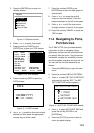
3. Press to select SET GO TO METHOD
and press the soft key EDIT. The SET
GO TO METHOD window appears.
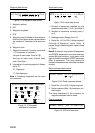
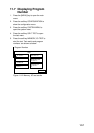
SET GO TO METHOD
1 POINT
35 POINT
WPT/PORT SER
Figure 11-12 SET GO TO METHOD window
4. Press to select WPT/PORT SER and
press the soft key ENTER or the
[ENTER] key.
5. Press the [PLOT] key once or twice to
return the plotter display.