


10-8
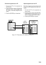
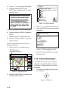
SETUP NMEA/DGPS PORT 2 menu
description
This menu should be set according to the
specifications of the equipment connected to
connectors PORT 1 (NMEA) and PORT 2
(DGPS) at the rear of the display unit. The
menu can be displayed by pressing the
[MENU] key followed by the soft keys CON-
FIGURATION and SETUP NMEA PORT 2.
For detailed information, see the installation
manual.
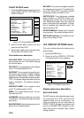
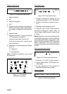
FORMAT
Selects data format of connected equipment;
NMEA0183 version 1.5, version 2.0,
RTVM104 (EXTRN), RTCM104 (INTRN) or
RTCM104 (OUTPUT). RTCM104 (INTRN) is
for GP-1850D only. The default setting is
RTVM104 (EXTRN).
The procedure for setting LAT/LON FORMAT
are similar to those for PORT 1. Note that
you cannot setup data sentences when you
select RTCM104 (INTRN) as the format. (A
level converter (IF-1432) is required when
using NMEA0183 format.)
LAT/LON FORMAT (GGA only)
Selects the seconds of latitude and longitude
positions in hundredths, thousandths or ten
thousandths.
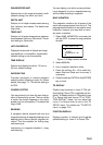
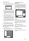
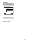
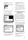
UPLOAD/DOWNLOAD DATA menu
This menu allows you to upload waypoint and
route data to a PC or download the same
data from a PC, via the DGPS connector at
the back of display unit. The menu can be
displayed by pressing the [MENU] key fol-
lowed by the soft keys CONFIGURATION
and UPLOAD/DOWNLOAD DATA. For de-
tailed information, see the installation manual.
For memory card, see chapter 9.
DWNLOAD
UPLOAD
DGPS 3D
DOWNLOAD WPT/RTE TO PC
UPLOAD WPT/RTE FROM PC
RETURN
SAVE DATA TO MEMORY CARD
LOAD DATA FROM MEMORY CARD
Figure 10-15 Upload/download menu
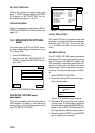
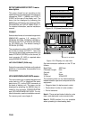
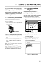
ANT XDR
TEMP/SPD
DGPS
NMEA
+ GND
1 3
2
-
12 - 24
VDC
Connect PC to DGPS
.
Figure 10-16 Display unit, rear view
Set communication software on the PC as
follows:
Baud Rate: 4800 bps
Character Length: 8 bit
Stop bit: 1 bit
Parity: None
X Control: XON/XOFF
The following data can be downloaded/up-
loaded between a personal computer and this
equipment.
• Waypoint data (In alphanumeric order)
• Route data (In order of route number)
• End of sentence
Note 1: There are two kinds of data for route
data: route data and route comment data.
Note 2: DGPS position fix is not available
when uploading or downloading data.