


11-6
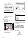
DEPTH INFO soft key:
Turns the DEPTH
INFO display on/off and sets it color in
FURUNO chart, or selects the depth areas
limit and spot sounding & bathymetric range
in C-MAP NT-FP chart.
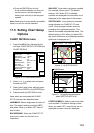
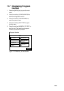
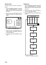
1. While displaying chart details menu,
press the soft key DEPTH INFO to show
the following display.
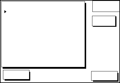
DGPS 3D
RETURN
DEPTH
INFO
EDIT
DEPTH < 10 m
DEPTH = 10 m
DEPTH > 10 m
DEPTH INFO
RED
YELLOW
LIGHT BLUE
RED
FOR FURUNO CHART
10 m : APPROX. 30 ft or 5 fa
FOR C-MAP CHART
SHADE CHANGE DPTH
SPOT SOUNDING &
0020, 0164 ft
0033~3000 ft
BATHYMETRIC RANGE
Figure 11-20 DEPTH INFO display
2. Press or to select item and press
the soft key EDIT or enter the appropriate
value by using numeric keys.
3. Select option with cursor pad and press
the soft key ENTER or the [ENTER] key.
4. Press the soft key RETURN several
times to finish.
SHADE CHANGE DPTH:
Sets two
values in the range of Depth Limit on the
DEPTH INFO display when the C-MAP
NT-FP chart is used. The Depth Areas
are shown on the screen in three colors
depending on depth.
0 to left value: Blue
left value to right value: Light-blue
greater than right value: Light-gray
(Maximum value: 12000 meter or
39369 ft)
In Figure 11-20, as the following,
0 - 20 ft: Blue
20 - 164 ft: Light-blue
greater than 164 ft: Light-gray
Note 1:
Depth data depends on the
registered value at "depth area". (See
page 1.)
Note 2:
It may be difficult to distinguish
colors of track and mark/line in sea areas
painted in light-blue or green.
SPOT SOUNDING &
BATHYMETRIC RANGE:
Sets the depth
range to display the spot sounding on the
C-MAP NT-FP chart. The depth range
you set is displayed red.
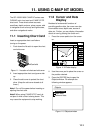
11.6 Selecting Chart
Scale/Range
Chart scale (range) may be selected with the
soft key ZOOM IN or ZOOM OUT. ZOOM IN
expands the chart; ZOOM OUT shrinks it.
The range selected is momentarily displayed
at the lower left-hand corner.
Note:
When the display is expanded or
shrunk beyond the range of the chart card in
use the chart is not displayed, and an
appropriate chart icon appears.