


10-5
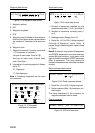
POS SMOOTHING
When the DOP or receiving condition is un-
favorable, the GPS fix may change greatly,
even if the vessel is dead in water. This
change can be reduced by smoothing the raw
GPS fixes. A setting between 000 to 999 is
available. The higher setting the more
smoothed the raw data, however too high a
setting shows response time to change in
latitude and longitude. This is especially no-
ticeable at high ship’s speeds. 000 is the
normal setting; increase the setting if the GPS
fix changes greatly.
SPD/CSE SMOOTHING
During position fixing, ship’s velocity (speed
and course) is directly measured by receiv-
ing GPS satellite signals. The raw velocity
data may change randomly depending on re-
ceiving conditions and other factors. You can
reduce this random variation by increasing
the smoothing. Like with latitude and longi-
tude smoothing, the higher the speed and
course smoothing the more smoothed the
raw data. If the setting is too high, however,
the response to speed and course change
slows. For no smoothing, enter all zeroes.
The default setting is 5 (sec).
GPS SPEED AVE
Calculation of ETA is based on average ship’s
speed over a given period. If the period is
too long or too short calculation error will re-
sult. Change this setting if calculation error
occurs. The default setting is 60 seconds,
which is suitable for most conditions.
LAT OFFSET, LON OFFSET
GPS generated position may be off by some
seconds due to GPS signal variation. You
may apply an offset to GPS position to refine
position accuracy.
DISABLE SATELLITE
Every GPS satellite is broadcasting abnor-
mal satellite number(s) in it’s Almanac, which
contains general orbital data about all GPS
satellites, including those which are malfunc-
tioning. Using this information, the GPS re-
ceiver automatically eliminates any
malfunctioning satellite from the GPS satel-
lite schedule. However, the Almanac some-
times may not contain this information. If you
hear about a malfunctioning satellite from
another source, you can disable it manually.
Enter satellite number (max. 3 satellites) in
two digits and press the soft key ENTER or
the [ENTER] key.
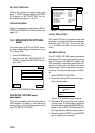
LATITUDE, LONGITUDE
The default latitude and longitude position is
San Francisco, USA (38.00.00’N,
123.00.000’W). When the unit is turned on
first the first time it begins searching for its
actual position. To lessen the time required
to find position, you may enter your position
manually. To switch from North to South and
vice versa, use the soft key N<-->S, and to
switch from West to East and vice versa, use
the soft key W<-->E. Finally, press the soft
key ENTER or the [ENTER] key.
ANT. HEIGHT
Enter the height of the antenna unit above
sea surface. For further details refer to the
installation manual. The default setting is 5
m.
FIX MODE
You can choose the position-fixing mode from
2D or 2D/3D. 2D requires three satellites to
fix position; 2D/3D requires three or four sat-
ellites, whichever is available. The default set-
ting is 2D/3D.