


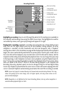
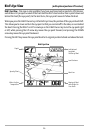
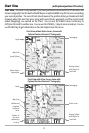

Chart View (with optional-purchase GPS receiver)
Chart View - This view is only available if you have purchased and connected a GPS Receiver, and
shows cartography from the built-in World Map or an optional MMC map for the area surrounding
your current position. The current track (also known as the position history or breadcrumb trail)
showing where the boat has been, along with saved tracks, waypoints, and the current route
(when navigating), are overlaid on the chart. You can use the 4-WAY Cursor Control key to
shift/pan the chart to another area. You can use the ZOOM (+/-) keys to zoom in and out. You can
use the INFO key to get information on the chart objects near the cursor.
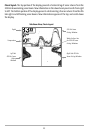
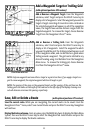
Chart View with Active Cursor, shown with
Optional-Purchase Navionics® Cartography
Depth
Cartography
Latitude and
Longitude
Position of
Cursor
Bearing of Boat
with Respect to
True North
Distance to
the Cursor
and Bearing
to Cursor
Map Scale
Active Cursor
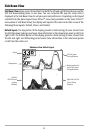
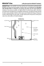
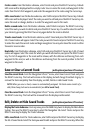
Chart View without Active Cursor, shown with
Optional-Purchase Navionics® Cartography
Depth
Cartography
Speed Of Boat
Bearing of Boat
with Respect to
True North
Water Surface
Temperature
Map Scale
27