


22
English
NAVIONICS Electronic Charts
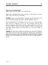
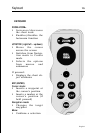
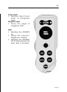
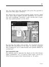
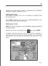
Press GOTO to display the menu, select SETUP/DISPLAY, then
PRESENTATION (INTER. or US).
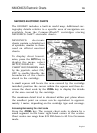
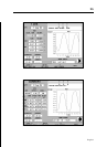
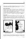
Depth contours
This function allows the user to select the display of depth
contours; the options available are:
OFF: no depth contour displayed
5m: display of contours only with depths up to 5 meters
10m: display of contours only with depths up to 10 meters
20m: display of contours only with depths up to 20 meters
ALL: all depth contours displayed
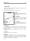
Safety contours
This function allows the user to display the depth areas cor-
responding to the safety contour desired. The options avail-
able are:
OFF: no depth area displayed
2m: areas with depths up to 2 meters in dark blue
5m: areas with depths up to 2 meters in dark blue, up to
5 meters in blue
10m: areas with depths up to 5 meters in dark blue, up to
10 meters in blue
20m: areas with depths up to 10 meters in dark blue, up to
20 meters in blue
The areas whose depths are over the limit set, and therefore
navigable under safety conditions, will be displayed in white.
Dryline areas are always displayed in green.
NOTE: The mentioned colors are those used in the DAY mode. In NIGHT mode, the
areas with depths over the limit set, and therefore navigable under safety conditions,
are in black, whereas the colors below the limit are dark blue for higher depths and
blue for lower depths (e.g. 5m: areas with depths up to 2m displayed in blue, up to
5m in dark blue).
Displaying chart details
The display of spot soundings, landmarks and other chart