


43
English
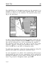
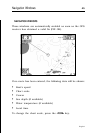
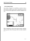
CURSOR MODE
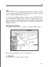
To plan a new route, or to append waypoints to the existing
route, move the cursor by using the joystick and press ENTER.
The GEONAV will display the following data:
• Route overall length
• Time to the end of the route (estimated on the speed value
manually entered in the ROUTE menu; see the Route Sec-
tion)
• Distance from the last waypoint to the cursor
• Chart scale
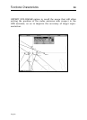
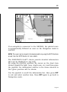
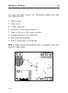
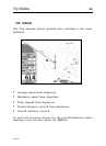
To edit the existing route, move the cursor by using the joy-
stick. The GEONAV will display the following data:
• Distance from the boat’s position to the cursor
• Time to arrive to the cursor
• Bearing from the boat’s position to the cursor
• Chart scale
Now it will be possible to move the cursor on a route item to
edit it, or press ENTER to lengthen the route by appending new
waypoints.